Browse "Cities & Populated Places"
-
Article
Guelph
Guelph, Ontario, incorporated as a city in 1879, population 143,740 (2021 census), 131,794 (2016 census). The City of Guelph, the seat of Wellington County, is located on the Speed River in south central Ontario, 96 km west of Toronto and 28 km east of Kitchener-Waterloo. This industrial and educational centre is set in the heart of a highly productive agricultural region.
"https://d2ttikhf7xbzbs.cloudfront.net/guelph/mapjpg.jpg" // resources/views/front/categories/view.blade.php
https://d2ttikhf7xbzbs.cloudfront.net/guelph/mapjpg.jpg
-
Article
Guysborough
Guysborough, NS, Community, population 403 (2011c), 428 (2006c). Guysborough, the shire town of Guysborough County, is located on the east shore of mainland Nova Scotia on Chedabucto Bay, 51 km from the Canso Causeway.
"https://development.thecanadianencyclopedia.ca/images/tce_placeholder.jpg?v=e9dca980c9bdb3aa11e832e7ea94f5d9" // resources/views/front/categories/view.blade.php
https://development.thecanadianencyclopedia.ca/images/tce_placeholder.jpg?v=e9dca980c9bdb3aa11e832e7ea94f5d9
-
Article
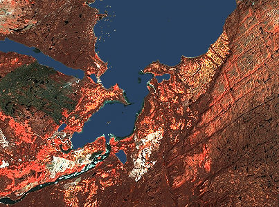
Gwaii Haanas
At 1,470 km2, Gwaii Haanas National Park Reserve, National Marine Conservation Area Reserve, and Haida Heritage Site (also known as Gwaii Haanas) encompasses 15 per cent of Haida Gwaii.
"https://d2ttikhf7xbzbs.cloudfront.net/media/media/77c96547-25d5-4295-a540-5a07340acb6c.jpg" // resources/views/front/categories/view.blade.php
https://d2ttikhf7xbzbs.cloudfront.net/media/media/77c96547-25d5-4295-a540-5a07340acb6c.jpg
-
Article
Haileybury
Haileybury, Ontario, unincorporated place, population 3,266 (2016 census) 3,462 (2011 census). Haileybury is located on the northwestern shore of Lake Timiskaming, 150 km north of North Bay. Incorporated as a town in 1904, it amalgamated with the town of New Liskeard and Dymond Township (incorporated 1901) to create the city of Temiskaming Shores in 2004.
"https://development.thecanadianencyclopedia.ca/images/tce_placeholder.jpg?v=e9dca980c9bdb3aa11e832e7ea94f5d9" // resources/views/front/categories/view.blade.php
https://development.thecanadianencyclopedia.ca/images/tce_placeholder.jpg?v=e9dca980c9bdb3aa11e832e7ea94f5d9
-
Article
Haines Junction
Haines Junction, Yukon, incorporated as a village in 1984, population 688 (2021 census), 613 (2016 census). The Village of Haines Junction is located in the Shakwak Valley of southwestern Yukon at the junction of the Haines and Alaska highways. With Kluane National Park and Reserve lying to the west, the village is the park's headquarters and offers a range of recreational activities, including trail riding and guided tours.
"https://d2ttikhf7xbzbs.cloudfront.net/hainesjunction/haines-junction-sunrise.jpg" // resources/views/front/categories/view.blade.php
https://d2ttikhf7xbzbs.cloudfront.net/hainesjunction/haines-junction-sunrise.jpg
-
Article
Haldimand County
Haldimand County, Ont, incorporated as a city in 2001, population 44 876 (2011c), 45 212 (2006c). The City of Haldimand County is situated on the north shore of LAKE ERIE along the GRAND RIVER, 20 km south of HAMILTON.
"https://development.thecanadianencyclopedia.ca/images/tce_placeholder.jpg?v=e9dca980c9bdb3aa11e832e7ea94f5d9" // resources/views/front/categories/view.blade.php
https://development.thecanadianencyclopedia.ca/images/tce_placeholder.jpg?v=e9dca980c9bdb3aa11e832e7ea94f5d9
-
Article
Halifax
Halifax, Nova Scotia, incorporated as a city in 1841, population 439,819 (2021 census), 403,131 (2016 census). Halifax is the capital of Nova Scotia and the largest urban area in Atlantic Canada. On 1 April 1996 Halifax was amalgamated with neighbouring communities to form the Halifax Regional Municipal Government. Halifax Regional Municipality occupies a strategic and central location on the province's east coast and is one of the world's largest harbours. Sometimes called "Warden of the North" for its historic military role, today it is a major regional centre for Atlantic Canada's economy.
"https://d2ttikhf7xbzbs.cloudfront.net/media/media/f3b5c3e8-74d8-4d23-be7b-429777f9a0f3.jpg" // resources/views/front/categories/view.blade.php
https://d2ttikhf7xbzbs.cloudfront.net/media/media/f3b5c3e8-74d8-4d23-be7b-429777f9a0f3.jpg
-
Article
Sanirajak
Sanirajak, Nunavut, incorporated as a hamlet in 1978, population 891 (2021 census), 848 (2016 census). Sanirajak, previously known as Hall Beach, is located on the east shore of the Melville Peninsula.
"https://development.thecanadianencyclopedia.ca/images/tce_placeholder.jpg?v=e9dca980c9bdb3aa11e832e7ea94f5d9" // resources/views/front/categories/view.blade.php
https://development.thecanadianencyclopedia.ca/images/tce_placeholder.jpg?v=e9dca980c9bdb3aa11e832e7ea94f5d9
-
Article
Halton Hills
Halton Hills, Ontario, incorporated as a town in 1974, population 62,951 (2021 census), 61,161 (2016 census). Halton Hills is located approximately 45 km west of Toronto and was created by the amalgamation of Acton, Georgetown and Esquesing Township. The town also encompasses several hamlets — Ballinafad, Glen Williams, Stewarttown, Limehouse, Glen Lawson, Speyside, Ashgrove, Crewson’s Corners, Bannockburn, Henderson’s Corners, Whaley’s Corners, Mansewood, Hornby, Silver Creek, Terra Cotta and Norval. From 1926 to 1935, Norval was home to Lucy Maud Montgomery, author of Anne of Green Gables.
"https://d2ttikhf7xbzbs.cloudfront.net/media/media/bea43b6e-722e-4df1-832a-44dba7c585e5.jpg" // resources/views/front/categories/view.blade.php
https://d2ttikhf7xbzbs.cloudfront.net/media/media/bea43b6e-722e-4df1-832a-44dba7c585e5.jpg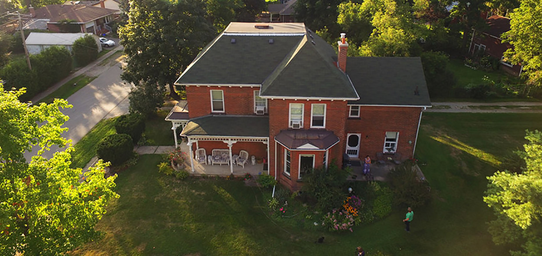
-
Article
Hamilton
Hamilton, Ontario, incorporated as a city in 1846, population 569,353 (2021 census), 536,917 (2016 census). The City of Hamilton is situated at the west end of Lake Ontario, on Burlington Bay, 68 km southwest of Toronto, and 66 km west of Niagara Falls and the American border. As part of the reorganization of municipal governments in Ontario, the boundaries of the city were enlarged in 2001 to include much of the surrounding suburban and rural area, including the former towns of Ancaster, Dundas, Flamborough and Stoney Creek, and the former township of Glanbrook. The city is Canada's largest steel producer and a major Great Lakes port.
"https://d2ttikhf7xbzbs.cloudfront.net/media/media/43375d5d-a5ce-46af-9009-c05cc2f3957b.jpg" // resources/views/front/categories/view.blade.php
https://d2ttikhf7xbzbs.cloudfront.net/media/media/43375d5d-a5ce-46af-9009-c05cc2f3957b.jpg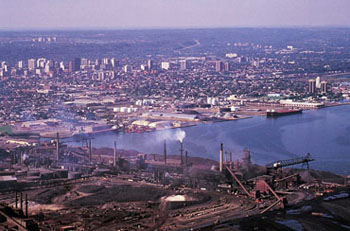
-
Article
Hampton
Hampton, NB, incorporated as a town in 1991, population 4292 (2011c), 4004 (2006c). The Town of Hampton is situated 37 km northeast of SAINT JOHN on the Kennebecasis River.
"https://development.thecanadianencyclopedia.ca/images/tce_placeholder.jpg?v=e9dca980c9bdb3aa11e832e7ea94f5d9" // resources/views/front/categories/view.blade.php
https://development.thecanadianencyclopedia.ca/images/tce_placeholder.jpg?v=e9dca980c9bdb3aa11e832e7ea94f5d9
-
Article
Hanna
Hanna, Alta, incorporated as a town in 1914, population 2673 (2011c), 2847 (2006c). The Town of Hanna is situated 219 km northeast of Calgary and was named after David B. HANNA, 3rd vice-president of the Canadian Northern Railway, and was first settled in 1912.
"https://development.thecanadianencyclopedia.ca/images/tce_placeholder.jpg?v=e9dca980c9bdb3aa11e832e7ea94f5d9" // resources/views/front/categories/view.blade.php
https://development.thecanadianencyclopedia.ca/images/tce_placeholder.jpg?v=e9dca980c9bdb3aa11e832e7ea94f5d9
-
Article
Hanover (Man)
Hanover, Manitoba, incorporated as a rural municipality in 1881, population 14 026 (2011c), 11 871 (2006c). The Rural Municipality of Hanover is located southeast of Winnipeg, encompasses the communities of Blumenort, Grunthal, Kleefeld, Mitchell, New Bothwell, Randolph and Sarto.
"https://development.thecanadianencyclopedia.ca/images/tce_placeholder.jpg?v=e9dca980c9bdb3aa11e832e7ea94f5d9" // resources/views/front/categories/view.blade.php
https://development.thecanadianencyclopedia.ca/images/tce_placeholder.jpg?v=e9dca980c9bdb3aa11e832e7ea94f5d9
-
Article
Hanover (Ont)
Hanover, Ont, incorporated as a town in 1904, population 7490 (2011c), 7147 (2006c). The Town of Hanover is located 70 km southwest of OWEN SOUND on the Saugeen River.
"https://d2ttikhf7xbzbs.cloudfront.net/media/media/0ae492cf-0c8f-489c-9da4-cdd28d818051.jpg" // resources/views/front/categories/view.blade.php
https://d2ttikhf7xbzbs.cloudfront.net/media/media/0ae492cf-0c8f-489c-9da4-cdd28d818051.jpg
-
Article
Happy Valley-Goose Bay
Happy Valley-Goose Bay, Newfoundland and Labrador, incorporated as a town in 1973, population 8,109 (2016 census), 7,552 (2011 census). The town of Happy Valley-Goose Bay is the result of the amalgamation of two towns situated at the western end of Hamilton Inlet, Labrador. The community began with the construction of an air base during the Second World War. It remains home to a Canadian Forces Base and a small civilian population.
"https://d2ttikhf7xbzbs.cloudfront.net/media/media/dcdb9156-1ed7-43df-b8d3-36f7d617cd41.jpg" // resources/views/front/categories/view.blade.php
https://d2ttikhf7xbzbs.cloudfront.net/media/media/dcdb9156-1ed7-43df-b8d3-36f7d617cd41.jpg