Browse "Places"
-
Collection
New France
France was a colonial power in North America from the early 16th century, the age of European discoveries and fishing expeditions, to the early 19th century, when Napoléon Bonaparte sold Louisiana to the United States. French presence in North America was marked by economic exchanges with Indigenous peoples, but also by conflicts, as the French attempted to control this vast territory. The French colonial enterprise was also spurred by religious motivation as well as the...
"https://d2ttikhf7xbzbs.cloudfront.net/media/media/d5ecd339-fb6d-406e-b82d-62130a227e1c.jpg" // resources/views/front/categories/view.blade.php
https://d2ttikhf7xbzbs.cloudfront.net/media/media/d5ecd339-fb6d-406e-b82d-62130a227e1c.jpg
-
Article
New France (Plain-Language summary)
New France was a French colony in North America. By the early 1740s, France controlled what is known today as the Maritime provinces, much of modern-day Ontario and Quebec, and the Hudson Bay region. The territory also stretched from today’s Northeastern United States to the Gulf of Mexico. Quebec City was the center of culture, society and economics. The French living in New France created a distinct culture. The French population of New France were known as habitants. Many habitants had a better life in New France than peasants in France. That said, not many people from France wanted to emigrate to New France. Most people in France thought New France was too cold and very dangerous. Because there was little immigration, New France had a very small population. In 1763, approximately 70,000 French colonists lived in New France. (See Population Settlement of New France.) This small population made New France weak. It was one of the most important reasons why New France was taken over by Britain in 1763. (This article is a plain-language summary of New France. If you are interested in reading about this topic in more depth, please see our full-length entry, New France.)
"https://d2ttikhf7xbzbs.cloudfront.net/NewFrance/New_France_historical_map.png" // resources/views/front/categories/view.blade.php
https://d2ttikhf7xbzbs.cloudfront.net/NewFrance/New_France_historical_map.png
-
Article
New Glasgow
New Glasgow, NS, incorporated as a town in 1875, population 9562 (2011c), 9455 (2006c). The Town of New Glasgow is located on the East River of Pictou 15 km southeast of Pictou.
"https://development.thecanadianencyclopedia.ca/images/tce_placeholder.jpg?v=e9dca980c9bdb3aa11e832e7ea94f5d9" // resources/views/front/categories/view.blade.php
https://development.thecanadianencyclopedia.ca/images/tce_placeholder.jpg?v=e9dca980c9bdb3aa11e832e7ea94f5d9
-
Article
New Maryland
New Maryland includes a number of historic buildings, including the Anglican church and Victoria Hall. It was the site of the last fatal duel in the province in 1821.
"https://d2ttikhf7xbzbs.cloudfront.net/media/media/d2d9fbdd-77c8-46bf-80c4-6ebaf8dab8e0.jpg" // resources/views/front/categories/view.blade.php
https://d2ttikhf7xbzbs.cloudfront.net/media/media/d2d9fbdd-77c8-46bf-80c4-6ebaf8dab8e0.jpg
-
Article
New Richmond
Although New Richmond is today about 80% French-speaking, its history is steeped in cultural diversity.
"https://d2ttikhf7xbzbs.cloudfront.net/media/media/9616645e-ad72-48e7-9556-6507df6a0e92.jpg" // resources/views/front/categories/view.blade.php
https://d2ttikhf7xbzbs.cloudfront.net/media/media/9616645e-ad72-48e7-9556-6507df6a0e92.jpg
-
Article
New Tecumseth
New Tecumseth, Ont, incorporated as a town in 1991, population 30 234 (2011c), 27 701 (2006c).
"https://development.thecanadianencyclopedia.ca/images/tce_placeholder.jpg?v=e9dca980c9bdb3aa11e832e7ea94f5d9" // resources/views/front/categories/view.blade.php
https://development.thecanadianencyclopedia.ca/images/tce_placeholder.jpg?v=e9dca980c9bdb3aa11e832e7ea94f5d9
-
Article
New-Wes-Valley
New-Wes-Valley, NL, incorporated as a town in 1992, population 2265 (2011c), 2485 (2006c). The Town of New-Wes-Valley is located on the northern coast of BONAVISTA BAY.
"https://development.thecanadianencyclopedia.ca/images/tce_placeholder.jpg?v=e9dca980c9bdb3aa11e832e7ea94f5d9" // resources/views/front/categories/view.blade.php
https://development.thecanadianencyclopedia.ca/images/tce_placeholder.jpg?v=e9dca980c9bdb3aa11e832e7ea94f5d9
-
Article
New Westminster
New Westminster, British Columbia, incorporated as a city in 1860, population 78,916 (2021 census), 70,996 (2016 census). The city of New Westminster is located on the north bank of the Fraser River, 20 km east of Vancouver. Governor James Douglas established New Westminster in 1859 as the capital of British Columbia. The Royal Engineers surveyed the city and Queen Victoria named it. As a result, New Westminster’s nickname is “The Royal City.” New Westminster is western Canada’s oldest city.
"https://d2ttikhf7xbzbs.cloudfront.net/media/media/8405cd89-59b7-4b0f-b434-ec1d2f55f2c1.jpg" // resources/views/front/categories/view.blade.php
https://d2ttikhf7xbzbs.cloudfront.net/media/media/8405cd89-59b7-4b0f-b434-ec1d2f55f2c1.jpg
-
Article
Music in New Westminster
City east of Vancouver near the mouth of the Fraser River. After its designation (1859, incorporation 1860) as the capital city of British Columbia it was named New Westminster by Queen Victoria, and hence nicknamed 'The Royal City.
"https://development.thecanadianencyclopedia.ca/images/tce_placeholder.jpg?v=e9dca980c9bdb3aa11e832e7ea94f5d9" // resources/views/front/categories/view.blade.php
https://development.thecanadianencyclopedia.ca/images/tce_placeholder.jpg?v=e9dca980c9bdb3aa11e832e7ea94f5d9
-
Timelines
Newfoundland and Labrador
Newfoundland, the youngest of the Canadian provinces, joined Confederation in 1949. Some portion of its coast was undoubtedly one of the first parts of the continent seen by Europeans. Its total area is 405, 720 km2, of which Labrador makes up almost three-quarters (294,330 km2).
"https://d2ttikhf7xbzbs.cloudfront.net/media/media/53e7a7d6-7939-4450-81d0-3d467d000af0.jpg" // resources/views/front/categories/view.blade.php
https://d2ttikhf7xbzbs.cloudfront.net/media/media/53e7a7d6-7939-4450-81d0-3d467d000af0.jpg
-
Article
Newfoundland and Labrador
Newfoundland, the youngest of the Canadian provinces, joined the Confederation in 1949. Some portion of its coast was undoubtedly one of the first parts of the continent seen by Europeans. Its total area is 405,720 km2, of which Labrador makes up almost three-quarters (294,330 km2). The island of Newfoundland is the easternmost region of Canada, while Labrador is located on the mainland to the northwest. Since John Cabot's arrival on the “new isle” the island has been referred to as Terra Nova, or in English, Newfoundland. Labrador probably received its name from the Portuguese designation, "Terra del Lavradors."
"https://d2ttikhf7xbzbs.cloudfront.net/media/media/53e7a7d6-7939-4450-81d0-3d467d000af0.jpg" // resources/views/front/categories/view.blade.php
https://d2ttikhf7xbzbs.cloudfront.net/media/media/53e7a7d6-7939-4450-81d0-3d467d000af0.jpg
-
Article
Newfoundland and Labrador and Confederation
Attempts to bring Newfoundland into Confederation in the 1860s and 1890s were met with lukewarm interest in the colony. In 1934, Newfoundland was in bankruptcy during the Great Depression. It suspended responsible government and accepted an unelected Commission Government directed by Britain. In a 1948 referendum, Newfoundlanders were given the choice to either continue with the Commission Government, join Canada, or seek a return to responsible government as an independent dominion. The independence option won the first vote. But the Confederation option won a run-off vote with 52.3 percent support. The British and Canadian parliaments approved of the union. Newfoundland became Canada’s 10th province on 31 March 1949. In 2001, the province’s name was officially changed to Newfoundland and Labrador.
"https://d2ttikhf7xbzbs.cloudfront.net/TCEImages/f6d1eaf9-8a3d-4e63-b541-3f932d9b4746.jpg" // resources/views/front/categories/view.blade.php
https://d2ttikhf7xbzbs.cloudfront.net/TCEImages/f6d1eaf9-8a3d-4e63-b541-3f932d9b4746.jpg
-
Editorial
Editorial: How the “Canadianized” Community of Newfoundland Joined Canada
The following article is an editorial written by The Canadian Encyclopedia staff. Editorials are not usually updated. When the Parliament Buildings in Ottawa were repaired after a fire during the First World War, stone plaques were erected over the entrance to the Peace Tower. There were ten of them — nine bearing the coats of arms of the provinces and one left bare, to await the day when Newfoundlandjoined Canada.
"https://development.thecanadianencyclopedia.ca/images/tce_placeholder.jpg?v=e9dca980c9bdb3aa11e832e7ea94f5d9" // resources/views/front/categories/view.blade.php
https://development.thecanadianencyclopedia.ca/images/tce_placeholder.jpg?v=e9dca980c9bdb3aa11e832e7ea94f5d9
-
Article
Newmarket
Newmarket, Ontario, incorporated as a town in 1880, population 87,942 (2021 census), 84,224 (2016 census). Newmarket’s modern boundaries were created in 1971 from the town itself, and portions of the townships of King, East Gwillimbury, and Whitchurch (see Whitchurch-Stouffiville). Located within York Region, Newmarket is in the Toronto Census Metropolitan Area. Throughout history, the Newmarket area has been home to different Indigenous groups, namely the Wendat (Huron), Tionontati (Petun), Haudenosaunee and the Anishinaabeg. The land is covered by Treaty 13 and the Williams Treaties.
"https://d2ttikhf7xbzbs.cloudfront.net/media/media/2143d913-8b18-4c06-8a1f-f540e3d5df7d.jpg" // resources/views/front/categories/view.blade.php
https://d2ttikhf7xbzbs.cloudfront.net/media/media/2143d913-8b18-4c06-8a1f-f540e3d5df7d.jpg
-
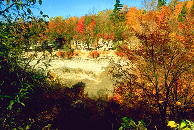
Article
Niagara Escarpment
The Niagara Escarpment, in its Ontario portion, is 725 km long, covering 1923 km2, with a maximum height of 335 m.
"https://d2ttikhf7xbzbs.cloudfront.net/media/media/5e74cb9f-53c2-453f-8ffd-322cbcf683cb.jpg" // resources/views/front/categories/view.blade.php
https://d2ttikhf7xbzbs.cloudfront.net/media/media/5e74cb9f-53c2-453f-8ffd-322cbcf683cb.jpg