Article
Campbell River
Campbell River, BC, incorporated as a city in 2005, population 31 186 (2011c), 29 572 (2006c). The City of Campbell River was formerly a village (1947) and a district municipality (1964) before receiving civic status in 2005.
Signing up enhances your TCE experience with the ability to save items to your personal reading list, and access the interactive map.
Create AccountArticle
Campbell River, BC, incorporated as a city in 2005, population 31 186 (2011c), 29 572 (2006c). The City of Campbell River was formerly a village (1947) and a district municipality (1964) before receiving civic status in 2005.
"https://development.thecanadianencyclopedia.ca/images/tce_placeholder.jpg?v=e9dca980c9bdb3aa11e832e7ea94f5d9" // resources/views/front/categories/view.blade.phphttps://development.thecanadianencyclopedia.ca/images/tce_placeholder.jpg?v=e9dca980c9bdb3aa11e832e7ea94f5d9

Article
Campbellton, NB, incorporated as a city in 1958, population 7385 (2011c), 7384 (2006c). The City of Campbellton is the administrative centre of Restigouche County. Campbellton is located on the Québec border near the mouth of the RESTIGOUCHE RIVER.
"https://development.thecanadianencyclopedia.ca/images/tce_placeholder.jpg?v=e9dca980c9bdb3aa11e832e7ea94f5d9" // resources/views/front/categories/view.blade.phphttps://development.thecanadianencyclopedia.ca/images/tce_placeholder.jpg?v=e9dca980c9bdb3aa11e832e7ea94f5d9
Article
Campobello Island abuts the border with the US in PASSAMAQUODDY BAY , on the south coast of New Brunswick. Sovereignty over the ruggedly picturesque island was early in dispute, but passed to NB by convention in 1817. The
"https://d2ttikhf7xbzbs.cloudfront.net/media/media/364b3dab-46ce-450c-8e44-125fe9dd20d3.jpg" // resources/views/front/categories/view.blade.phphttps://d2ttikhf7xbzbs.cloudfront.net/media/media/364b3dab-46ce-450c-8e44-125fe9dd20d3.jpg

Article
Camrose, Alberta, incorporated as a city in 1955, population 18,742 (2016 census), 17,286 (2011 census). The city of Camrose, located 97 km southeast of Edmonton, is a distributing, medical, government and manufacturing centre for a rich, mixed-farming area.
"https://development.thecanadianencyclopedia.ca/images/tce_placeholder.jpg?v=e9dca980c9bdb3aa11e832e7ea94f5d9" // resources/views/front/categories/view.blade.phphttps://development.thecanadianencyclopedia.ca/images/tce_placeholder.jpg?v=e9dca980c9bdb3aa11e832e7ea94f5d9
Article
The name “Canada,” is derived from the Iroquoian word kanata, meaning a village or settlement. On 13 August 1535, as Jacques Cartier was nearing Île d'Anticosti, two Indigenous youths he was bringing back from France informed him that the route to Canada (“chemin de Canada”) lay to the south of the island. By Canada they meant the village of Stadacona, on the future site of Quebec City. Cartier used the word in that sense, but also referred to “the province of Canada,” meaning the area subject to Donnacona, chief at Stadacona. The name was soon applied to a much larger region. The “Harleian” world map of c. 1547, the first to show the discoveries made on Cartier's second voyage, applied it to an area north of the gulf and river St. Lawrence. By 1550 maps were also placing the name south of the river. (See also Cartography in Canada: 1500s.)
"https://d2ttikhf7xbzbs.cloudfront.net/media/new_article_images/CartographyInCanada1500s/DesceliersMap1546.jpg" // resources/views/front/categories/view.blade.phphttps://d2ttikhf7xbzbs.cloudfront.net/media/new_article_images/CartographyInCanada1500s/DesceliersMap1546.jpg

Article
The Canada Aviation and Space Museum has the most extensive aviation collection in Canada. Located in Ottawa, the museum focuses on the history of Canadian aviation in an international context. Its collection includes more than 130 aircraft and artifacts.
"https://d2ttikhf7xbzbs.cloudfront.net/media/media/8e9fd784-494b-45e6-8b61-9ddb0f1d563d.jpg" // resources/views/front/categories/view.blade.phphttps://d2ttikhf7xbzbs.cloudfront.net/media/media/8e9fd784-494b-45e6-8b61-9ddb0f1d563d.jpg

Article
In 1841, Britain united the colonies of Upper and Lower Canada into the Province of Canada. This was in response to the violent rebellions of 1837–38. The Durham Report (1839) laid out the guidelines to create the new colony with the Act of Union in 1840. The Province of Canada was made up of Canada West (formerly Upper Canada) and Canada East (formerly Lower Canada). The two regions were governed jointly until Confederation in 1867. Canada West then became Ontario and Canada East became Quebec.
"https://d2ttikhf7xbzbs.cloudfront.net/media/new_article_images/PoliticsInOntario/Map_Canada_West_East.jpg" // resources/views/front/categories/view.blade.phphttps://d2ttikhf7xbzbs.cloudfront.net/media/new_article_images/PoliticsInOntario/Map_Canada_West_East.jpg

Article
Canada House, a distinctive symbol of Canadian interests in Britain, located in London's bustling Trafalgar Square.
"https://d2ttikhf7xbzbs.cloudfront.net/media/media/eace665f-b462-4eb7-b033-fa64d5bda978.jpg" // resources/views/front/categories/view.blade.phphttps://d2ttikhf7xbzbs.cloudfront.net/media/media/eace665f-b462-4eb7-b033-fa64d5bda978.jpg

Article
In 1841, Britain united the colonies of Upper and Lower Canada into the Province of Canada. This was in response to the violent rebellions of 1837–38. The Durham Report (1839) laid out the guidelines to create the new colony with the Act of Union in 1840. The Province of Canada was made up of Canada West (formerly Upper Canada) and Canada East (formerly Lower Canada). The two regions were governed jointly until Confederation in 1867. Canada West then became Ontario and Canada East became Quebec.
"https://development.thecanadianencyclopedia.ca/images/tce_placeholder.jpg?v=e9dca980c9bdb3aa11e832e7ea94f5d9" // resources/views/front/categories/view.blade.phphttps://development.thecanadianencyclopedia.ca/images/tce_placeholder.jpg?v=e9dca980c9bdb3aa11e832e7ea94f5d9
Article
The Canadian Broadcasting Centre was developed as the result of a proposal call process in which the Cadillac Fairview Corporation Limited was selected to develop the 9.3 acre site, owned by the CBC, and build the centre, which was then leased to the CBC on a long-term basis.
"https://development.thecanadianencyclopedia.ca/images/tce_placeholder.jpg?v=e9dca980c9bdb3aa11e832e7ea94f5d9" // resources/views/front/categories/view.blade.phphttps://development.thecanadianencyclopedia.ca/images/tce_placeholder.jpg?v=e9dca980c9bdb3aa11e832e7ea94f5d9
Article
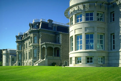
The Canadian Centre for Architecture (CCA) is both a museum of architecture and a research institute. It is located in Shaughnessy Village, a neighbourhood in downtown Montreal. Internationally renowned, the CCA is the primary Canadian institute devoted to the study of architecture. It was founded in 1979 by architect Phyllis Lambert to raise public awareness of the importance of architecture in society and to encourage innovation and university research regarding architecture.
"https://d2ttikhf7xbzbs.cloudfront.net/media/media/cccea479-6a06-49cb-9370-1aec65839121.jpg" // resources/views/front/categories/view.blade.phphttps://d2ttikhf7xbzbs.cloudfront.net/media/media/cccea479-6a06-49cb-9370-1aec65839121.jpg
Article
Canadian Forces Base (CFB) Borden has always been primarily a training base for the Canadian Forces (CF). It is located 80 km northwest of Toronto, and was named after Sir Frederick Borden, Laurier's militia minister (1896-1911).
"https://d2ttikhf7xbzbs.cloudfront.net/The-Memory-Project/image/2016_original.jpg" // resources/views/front/categories/view.blade.phphttps://d2ttikhf7xbzbs.cloudfront.net/The-Memory-Project/image/2016_original.jpg

Article
Canadian Forces Base Gagetown (or CFB Gagetown) functions primarily as the combat-training centre for the Canadian Army and comprises 111,000 hectares between Fredericton and Saint John, New Brunswick, west of the Saint John River.
"https://d2ttikhf7xbzbs.cloudfront.net/Black_Watch_Gagetown.jpg" // resources/views/front/categories/view.blade.phphttps://d2ttikhf7xbzbs.cloudfront.net/Black_Watch_Gagetown.jpg

Article
Renamed Canadian Forces Base Petawawa in 1968, the base has a total population of 5,000. As one of Canada's busiest operational bases, it is economically important to the adjacent town of Petawawa and nearby Pembroke.
"https://d2ttikhf7xbzbs.cloudfront.net/media/media/098aa086-dfcf-4c65-a548-365e130e24e4.jpg" // resources/views/front/categories/view.blade.phphttps://d2ttikhf7xbzbs.cloudfront.net/media/media/098aa086-dfcf-4c65-a548-365e130e24e4.jpg

Article
Shilo, Canadian Forces Base (CFB), is located on the western boundary of Manitoba's Spruce Woods Provincial Forest, 195 km west of Winnipeg and 25 km east of Brandon. A portion of the forest is leased to the federal government for the Shilo military reserve. The base is part of Land Force Western Area (LFWA), which was established in 1991, with its headquarters in Edmonton.
"https://d2ttikhf7xbzbs.cloudfront.net/The-Memory-Project/image/10280_original.jpg" // resources/views/front/categories/view.blade.phphttps://d2ttikhf7xbzbs.cloudfront.net/The-Memory-Project/image/10280_original.jpg
