Article
Canadian Forces Base Trenton
8 Wing/Canadian Forces Base Trenton is located 167 km east of Toronto on Lake Ontario's Bay of Quinte. Begun in 1929 on 384 ha of flat farmland adjacent to the town of Trenton.
Signing up enhances your TCE experience with the ability to save items to your personal reading list, and access the interactive map.
Create AccountArticle
8 Wing/Canadian Forces Base Trenton is located 167 km east of Toronto on Lake Ontario's Bay of Quinte. Begun in 1929 on 384 ha of flat farmland adjacent to the town of Trenton.
"https://d2ttikhf7xbzbs.cloudfront.net/media/media/8377e866-518b-4c25-9a3f-72d2f2cca799.jpg" // resources/views/front/categories/view.blade.phphttps://d2ttikhf7xbzbs.cloudfront.net/media/media/8377e866-518b-4c25-9a3f-72d2f2cca799.jpg

Article
During the Cold War, Canada stationed army and air force units abroad for the first time during peacetime. Soldiers and airmen began to arrive in the early 1950s, shortly after the Cold War began, and remained until 1993, after it ended. In total, more than 100,000 Canadian military personnel served in France and West Germany in that period.
"https://d2ttikhf7xbzbs.cloudfront.net/media/media/e011169341-v8.jpg" // resources/views/front/categories/view.blade.phphttps://d2ttikhf7xbzbs.cloudfront.net/media/media/e011169341-v8.jpg

Article
Canadian Government RailwaysCanadian Government Railways was the descriptive name of all federally owned railways in Canada from about the 1880s until 1918, when its operations were combined with the recently nationalized CANADIAN NORTHERN RAILWAY; in the following year the CANADIAN NATIONAL RAILWAYS were incorporated to operate both companies. The Canadian Government Railways, entrusted to the CN for operation in 1923, still exists as a component of the CN and has 4 principal constituents: the Intercolonial,...
"https://development.thecanadianencyclopedia.ca/images/tce_placeholder.jpg?v=e9dca980c9bdb3aa11e832e7ea94f5d9" // resources/views/front/categories/view.blade.phphttps://development.thecanadianencyclopedia.ca/images/tce_placeholder.jpg?v=e9dca980c9bdb3aa11e832e7ea94f5d9

Article
Rivers are part of our lives and our heritage. They are the threads that bind the fabric of nature and humanity together.
"https://development.thecanadianencyclopedia.ca/images/tce_placeholder.jpg?v=e9dca980c9bdb3aa11e832e7ea94f5d9" // resources/views/front/categories/view.blade.phphttps://development.thecanadianencyclopedia.ca/images/tce_placeholder.jpg?v=e9dca980c9bdb3aa11e832e7ea94f5d9
Article
The Canadian Music Hall of Fame was established in 1978 by the Canadian Academy of Recording Arts and Sciences (CARAS). It honours individuals or groups that have made an outstanding contribution to the international recognition of Canadian artists and music. For many years, a sole inductee was presented annually at the Juno Awards. Since 2019, multiple inductees have also been presented annually at a separate ceremony at the National Music Centre in Calgary.
"https://d2ttikhf7xbzbs.cloudfront.net/media/new_article_images/NationalMusicCentre/26137577257_571cc8e1b1_z.jpg" // resources/views/front/categories/view.blade.phphttps://d2ttikhf7xbzbs.cloudfront.net/media/new_article_images/NationalMusicCentre/26137577257_571cc8e1b1_z.jpg

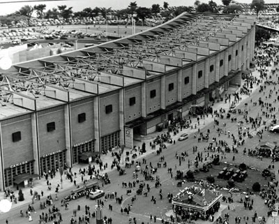
Article
The Canadian National Exhibition, Canada's largest annual exhibition and the fifth largest in North America, is held in Toronto for 18 days in late August.
"https://d2ttikhf7xbzbs.cloudfront.net/media/media/ad68fb7f-1f51-43c2-aa3b-ecd2a6f1f526.jpg" // resources/views/front/categories/view.blade.phphttps://d2ttikhf7xbzbs.cloudfront.net/media/media/ad68fb7f-1f51-43c2-aa3b-ecd2a6f1f526.jpg
Article
The Canadian Pacific Railway company (CPR) was incorporated in 1881. Its original purpose was the construction of a transcontinental railway, a promise to British Columbia upon its entry into Confederation (see Railway History). The railway — completed in 1885 — connected Eastern Canada to British Columbia and played an important role in the development of the nation. Built in dangerous conditions by thousands of labourers, including 15,000 Chinese temporary workers, the railway facilitated communication and transportation across the country. Over its long history, the Canadian Pacific Railway diversified its operations. The company established hotels, shipping lines and airlines, and developed mining and telecommunications industries (see Shipping Industry; Air Transport Industry). In 2001, Canadian Pacific separated into five separate and independent companies, with Canadian Pacific Railway returning to its origins as a railway company. CP, as it is branded today, has over 22,500 km of track across Canada and the United States. It is a public company and it trades on the Toronto Stock Exchange and the New York Stock Exchange under the symbol CP. In 2020, CP reported $7.71 billion in total revenues. This is the full-length entry about the Canadian Pacific Railway. For a plain-language summary, please see The Canadian Pacific Railway (Plain-Language Summary).
"https://d2ttikhf7xbzbs.cloudfront.net/media/media/c1bf1c65-a118-4b73-9ee5-5f9dccbd8ab8.jpg" // resources/views/front/categories/view.blade.phphttps://d2ttikhf7xbzbs.cloudfront.net/media/media/c1bf1c65-a118-4b73-9ee5-5f9dccbd8ab8.jpg

List
Canada has about 350,000 official place names. While many of these names honour people, a great many others reference physical or human geography. This list showcases the latter, highlighting names that point to the natural features of a place — take Montreal, for example — or how people interact with the land, be it through travel or settlement (as in Portage la Prairie, Manitoba). And, as with “Canada” itself, many of these names stem from an Indigenous word, or are themselves in an Indigenous language, such as Ulukhaktok, Northwest Territories (see also Largest Cities in Canada With an Indigenous Name).
"https://d2ttikhf7xbzbs.cloudfront.net/media/new_article_images/GeographyPlaceNamesList/WhiteRockBC.jpg" // resources/views/front/categories/view.blade.phphttps://d2ttikhf7xbzbs.cloudfront.net/media/new_article_images/GeographyPlaceNamesList/WhiteRockBC.jpg

Article
The Canadian War Museum, Canada's national museum of military history, was opened in 2005 on the south bank of the Ottawa River. The museum, originally begun in 1880 as an informal collection of military artifacts, was moved in 1967 to an archives building on Sussex Drive with most of the collection stored off-site. In 2001, the Federal Government announced the decision to fund the construction of a state-of-the art new building to be situated in the LeBreton Flats area of downtown Ottawa. Designed by Moriyama & Teshima Architects in a joint venture with Griffiths Rankin Cook Architects, the Museum opened in May 2005. Appropriately, its opening coincided with the 60th anniversary of the end of World War II in Europe and also the 125th anniversary of the museum itself.
"https://d2ttikhf7xbzbs.cloudfront.net/media/media/1cd591e9-f99b-48ed-8934-7b6ed5602bd9.jpg" // resources/views/front/categories/view.blade.phphttps://d2ttikhf7xbzbs.cloudfront.net/media/media/1cd591e9-f99b-48ed-8934-7b6ed5602bd9.jpg

Article
These 2 great journeys were first made just before the end of the 18th century, and by the same man. Alexander Mackenzie reached the mouth of the river which now bears his name in 1789, and was the first European to cross the North American continent (to Bella Coola) in 1793.
"https://d2ttikhf7xbzbs.cloudfront.net/media/media/32cb8906-b09c-4152-b17f-79e56a5c8714.jpg" // resources/views/front/categories/view.blade.phphttps://d2ttikhf7xbzbs.cloudfront.net/media/media/32cb8906-b09c-4152-b17f-79e56a5c8714.jpg

Article
The Candiac Development Corporation (now Developpements urbain Candiac), a group of Canadian and European investors, owned utilized farmland in the parishes of Saint-Constant, Delson, Saint-Philippe and the town of LA PRAIRIE.
"https://d2ttikhf7xbzbs.cloudfront.net/media/media/c7208d84-cf2c-4a5d-8d23-c8d52681a469.jpg" // resources/views/front/categories/view.blade.phphttps://d2ttikhf7xbzbs.cloudfront.net/media/media/c7208d84-cf2c-4a5d-8d23-c8d52681a469.jpg

Article
Canmore, Alta, incorporated as a town in 1966, population 12 288 (2011c), 12 039 (2006c). The Town of Canmore is located in the foothills of the Rocky Mountains, five km east of BANFF NATIONAL PARK.
"https://development.thecanadianencyclopedia.ca/images/tce_placeholder.jpg?v=e9dca980c9bdb3aa11e832e7ea94f5d9" // resources/views/front/categories/view.blade.phphttps://development.thecanadianencyclopedia.ca/images/tce_placeholder.jpg?v=e9dca980c9bdb3aa11e832e7ea94f5d9
Article
Cannington Manor, established 1882 when an Englishman, Capt Edward Michell Pierce, claimed 5 townships 65 km south of Whitewood, NWT (now in southeast Saskatchewan), the nearest point on the CPR.
"https://development.thecanadianencyclopedia.ca/images/tce_placeholder.jpg?v=e9dca980c9bdb3aa11e832e7ea94f5d9" // resources/views/front/categories/view.blade.phphttps://development.thecanadianencyclopedia.ca/images/tce_placeholder.jpg?v=e9dca980c9bdb3aa11e832e7ea94f5d9
Article
Canora, Sask, incorporated as a town in 1910, population 2219 (2011c), 2013 (2006c). The Town of Canora is located 50 km north of Yorkton. The community was a creation of the CANADIAN NORTHERN RAILWAY which laid steel through the
"https://development.thecanadianencyclopedia.ca/images/tce_placeholder.jpg?v=e9dca980c9bdb3aa11e832e7ea94f5d9" // resources/views/front/categories/view.blade.phphttps://development.thecanadianencyclopedia.ca/images/tce_placeholder.jpg?v=e9dca980c9bdb3aa11e832e7ea94f5d9
Article
Canso, NS, incorporated as a town in 1901, population 806 (2011c), 911 (2006c). The Town of Canso is located on Chedabucto Bay, on the northeastern shore of mainland Nova Scotia.
"https://development.thecanadianencyclopedia.ca/images/tce_placeholder.jpg?v=e9dca980c9bdb3aa11e832e7ea94f5d9" // resources/views/front/categories/view.blade.phphttps://development.thecanadianencyclopedia.ca/images/tce_placeholder.jpg?v=e9dca980c9bdb3aa11e832e7ea94f5d9