Article
Three Hills
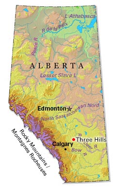
Three Hills, Alta, incorporated as a town in 1929, population 3198 (2011c), 3089 (2006c). The Town of Three Hills is located 128 km northeast of Calgary. Three Hills takes its name from 3 prominent hills to the north of the town.
Signing up enhances your TCE experience with the ability to save items to your personal reading list, and access the interactive map.
Create AccountArticle
Three Hills, Alta, incorporated as a town in 1929, population 3198 (2011c), 3089 (2006c). The Town of Three Hills is located 128 km northeast of Calgary. Three Hills takes its name from 3 prominent hills to the north of the town.
"https://d2ttikhf7xbzbs.cloudfront.net/media/media/5ecb9aa6-e6d7-420b-a068-c8a30e4d9c1c.jpg" // resources/views/front/categories/view.blade.phphttps://d2ttikhf7xbzbs.cloudfront.net/media/media/5ecb9aa6-e6d7-420b-a068-c8a30e4d9c1c.jpg
Article
Tillsonburg, Ont, incorporated as a town in 1872, population 15 301 (2011c), 14 822 (2006c). The Town of Tillsonburg is located in Oxford County, 40 km east of ST THOMAS. Founder George Tillson arrived in 1825 and opened a forge
"https://development.thecanadianencyclopedia.ca/images/tce_placeholder.jpg?v=e9dca980c9bdb3aa11e832e7ea94f5d9" // resources/views/front/categories/view.blade.phphttps://development.thecanadianencyclopedia.ca/images/tce_placeholder.jpg?v=e9dca980c9bdb3aa11e832e7ea94f5d9

Article
Tisdale, Sask, incorporated as a town in 1920, population 3180 (2011c), 3000 (2006c). The Town of Tisdale is located at a railway junction, 135 km southeast of Prince Albert. Originally called Doghide after nearby Doghide Creek
"https://development.thecanadianencyclopedia.ca/images/tce_placeholder.jpg?v=e9dca980c9bdb3aa11e832e7ea94f5d9" // resources/views/front/categories/view.blade.phphttps://development.thecanadianencyclopedia.ca/images/tce_placeholder.jpg?v=e9dca980c9bdb3aa11e832e7ea94f5d9
Article
Torbay, NL, incorporated as a town in 1972, population 7397 (2011c), 6281 (2006c). The Town of Torbay is located 10 km north of ST JOHN'S overlooking Torbay Bight.
"https://development.thecanadianencyclopedia.ca/images/tce_placeholder.jpg?v=e9dca980c9bdb3aa11e832e7ea94f5d9" // resources/views/front/categories/view.blade.phphttps://development.thecanadianencyclopedia.ca/images/tce_placeholder.jpg?v=e9dca980c9bdb3aa11e832e7ea94f5d9
Article
Tracadie-Sheila, NB, incorporated as a town in 1992, population 4933 (2011c), 4479 (2006c). The Town of Tracadie-Sheila is situated on the Gulf of ST LAWRENCE, 83 km southeast of BATHURST.
"https://development.thecanadianencyclopedia.ca/images/tce_placeholder.jpg?v=e9dca980c9bdb3aa11e832e7ea94f5d9" // resources/views/front/categories/view.blade.phphttps://development.thecanadianencyclopedia.ca/images/tce_placeholder.jpg?v=e9dca980c9bdb3aa11e832e7ea94f5d9
Article
Trenton, NS, incorporated as a town in 1911, population 2616 (2011c), 2741 (2006c). The Town of Trenton is located on the East River, immediately adjacent to New Glasgow.
"https://development.thecanadianencyclopedia.ca/images/tce_placeholder.jpg?v=e9dca980c9bdb3aa11e832e7ea94f5d9" // resources/views/front/categories/view.blade.phphttps://development.thecanadianencyclopedia.ca/images/tce_placeholder.jpg?v=e9dca980c9bdb3aa11e832e7ea94f5d9
Article
Trinity, NL, incorporated as a town in 1997, population 137 (2011c), 191 (2006c). The Town of Trinity is located on TRINITY BAY in northeast Newfoundland.
"https://d2ttikhf7xbzbs.cloudfront.net/media/media/58774878-3d11-4ee2-9eb0-03b03dad0d66.jpg" // resources/views/front/categories/view.blade.phphttps://d2ttikhf7xbzbs.cloudfront.net/media/media/58774878-3d11-4ee2-9eb0-03b03dad0d66.jpg

Article
Truro, Nova Scotia, incorporated as a town in 1875, population 12,954 (2021 census), 12,261 (2016 census). The Town of Truro is located along the Salmon River 100 km northeast of Halifax on Cobequid Bay, Minas Basin. The town derives its name from New England settlers and likely honours Truro in Cornwall, England.
"https://development.thecanadianencyclopedia.ca/images/tce_placeholder.jpg?v=e9dca980c9bdb3aa11e832e7ea94f5d9" // resources/views/front/categories/view.blade.phphttps://development.thecanadianencyclopedia.ca/images/tce_placeholder.jpg?v=e9dca980c9bdb3aa11e832e7ea94f5d9
Article
Twillingate, NL, incorporated as a town in 1962, population 2269 (2011c), 2448 (2006c). The Town of Twillingate is located on Twillingate Islands, Notre Dame Bay in northeast Newfoundland.
"https://development.thecanadianencyclopedia.ca/images/tce_placeholder.jpg?v=e9dca980c9bdb3aa11e832e7ea94f5d9" // resources/views/front/categories/view.blade.phphttps://development.thecanadianencyclopedia.ca/images/tce_placeholder.jpg?v=e9dca980c9bdb3aa11e832e7ea94f5d9
Article
Unity, Sask, incorporated as a town in 1919, population 2389 (2011c), 2147 (2006c). The Town of Unity is located in west-central Saskatchewan 70 km southwest of North Battleford. Settlement in the area commenced in 1904 and the
"https://development.thecanadianencyclopedia.ca/images/tce_placeholder.jpg?v=e9dca980c9bdb3aa11e832e7ea94f5d9" // resources/views/front/categories/view.blade.phphttps://development.thecanadianencyclopedia.ca/images/tce_placeholder.jpg?v=e9dca980c9bdb3aa11e832e7ea94f5d9
Article
Upper Island Cove, NL, incorporated as a town in 1965, population 1594 (2011c), 1667 (2006c). The Town of Upper Island Cove was created when two communities (Upper Island Cove and Spoon Cove) amalgamated. The town is located north of SPANIARD'S BAY on the northwest side of CONCEPTION BAY.
"https://development.thecanadianencyclopedia.ca/images/tce_placeholder.jpg?v=e9dca980c9bdb3aa11e832e7ea94f5d9" // resources/views/front/categories/view.blade.phphttps://development.thecanadianencyclopedia.ca/images/tce_placeholder.jpg?v=e9dca980c9bdb3aa11e832e7ea94f5d9
Article
Val-d'Or, Quebec, city incorporated in 1968, population 32,491 (2016 census), 31,862 (2011 census). Val-d'Or is located 95 km southeast of Rouyn-Noranda in northwestern Quebec's Abitibi-Témiscamingue region. The town is near the source of the Harricana River, one of the major rivers flowing north to James Bay. Val-d’Or’s name is linked to the gold rush, second in scale only to the Klondike, which took the area by storm in the mid-1930s. (See Gold Rushes in Canada.)
"https://development.thecanadianencyclopedia.ca/images/tce_placeholder.jpg?v=e9dca980c9bdb3aa11e832e7ea94f5d9" // resources/views/front/categories/view.blade.phphttps://development.thecanadianencyclopedia.ca/images/tce_placeholder.jpg?v=e9dca980c9bdb3aa11e832e7ea94f5d9
Article
Vegreville, Alberta, incorporated as a town in 1906, population 5,708 (2016 census), 5,717 (2011 census). The town of Vegreville is located in the parkland region of east-central Alberta, 100 km east of Edmonton. It serves a rich agricultural region specializing in grains and some livestock.
"https://d2ttikhf7xbzbs.cloudfront.net/media/media/b8c1d06f-d8cf-4165-8482-e6a2dca8f83d.jpg" // resources/views/front/categories/view.blade.phphttps://d2ttikhf7xbzbs.cloudfront.net/media/media/b8c1d06f-d8cf-4165-8482-e6a2dca8f83d.jpg

Article
Vermilion, Alta, incorporated as a town in 1906, population 3930 (2011c), 4036 (2006c). The Town of Vermilion is located on the Vermilion River 190 km east of Edmonton.
"https://development.thecanadianencyclopedia.ca/images/tce_placeholder.jpg?v=e9dca980c9bdb3aa11e832e7ea94f5d9" // resources/views/front/categories/view.blade.phphttps://development.thecanadianencyclopedia.ca/images/tce_placeholder.jpg?v=e9dca980c9bdb3aa11e832e7ea94f5d9
Article
Victoria, NL, incorporated as a town in 1971, population 1764 (2011c), 1769 (2006c). The Town of Victoria is located near CARBONEAR on the road between Carbonear and HEART'S CONTENT.
"https://development.thecanadianencyclopedia.ca/images/tce_placeholder.jpg?v=e9dca980c9bdb3aa11e832e7ea94f5d9" // resources/views/front/categories/view.blade.phphttps://development.thecanadianencyclopedia.ca/images/tce_placeholder.jpg?v=e9dca980c9bdb3aa11e832e7ea94f5d9