Browse "Places"
-
Article
Hells Gate
Hells Gate is a narrow rocky gorge of the Fraser River Canyon south of Boston Bar, British Columbia.
"https://d2ttikhf7xbzbs.cloudfront.net/media/media/3a0bfcc6-c4db-40cb-9d96-e5db248cc7e2.jpg" // resources/views/front/categories/view.blade.php
https://d2ttikhf7xbzbs.cloudfront.net/media/media/3a0bfcc6-c4db-40cb-9d96-e5db248cc7e2.jpg
-
Article
Helmcken Falls
Helmcken Falls is located on the Murtle River at the entrance to British Columbia's Wells Gray Provincial Park, an area noted for its many waterfalls. It is the highest in the park and fifth highest in Canada. Situated in the
"https://d2ttikhf7xbzbs.cloudfront.net/media/media/7ee6d9fa-b453-42f3-8c3b-f2a71dd7943f.jpg" // resources/views/front/categories/view.blade.php
https://d2ttikhf7xbzbs.cloudfront.net/media/media/7ee6d9fa-b453-42f3-8c3b-f2a71dd7943f.jpg
-
Article
Her Majesty's Theatre
Her (His) Majesty's Theatre. Montreal theatre located on Guy St and seating 1750 on a main floor and two balconies.
"https://development.thecanadianencyclopedia.ca/images/tce_placeholder.jpg?v=e9dca980c9bdb3aa11e832e7ea94f5d9" // resources/views/front/categories/view.blade.php
https://development.thecanadianencyclopedia.ca/images/tce_placeholder.jpg?v=e9dca980c9bdb3aa11e832e7ea94f5d9
-
Collection
Heritage Minutes
The Heritage Minutes collection is a bilingual series of history-focused public service announcements. Each 60-second short film depicts a significant person, event or story in Canadian history. They are produced by Historica Canada, the not-for-profit organization that also publishes this encyclopedia. First released in 1991, the Heritage Minutes have been shown on television, in cinemas and online. They have become a recognizable part of Canadian culture. The collection currently includes 100 episodes.
"https://d2ttikhf7xbzbs.cloudfront.net/media/media/1bfa3d45-2952-4f79-b7d4-4c6cb6601164.jpg" // resources/views/front/categories/view.blade.php
https://d2ttikhf7xbzbs.cloudfront.net/media/media/1bfa3d45-2952-4f79-b7d4-4c6cb6601164.jpg
-
Article
Heritage Trail
Hundreds of trails are now found from coast to coast in Canada, installed and run by national and provincial parks, the Canadian Wildlife Service, tourist departments, conservation authorities, museums, universities, schools, botanical gardens and private agencies.
"https://development.thecanadianencyclopedia.ca/images/tce_placeholder.jpg?v=e9dca980c9bdb3aa11e832e7ea94f5d9" // resources/views/front/categories/view.blade.php
https://development.thecanadianencyclopedia.ca/images/tce_placeholder.jpg?v=e9dca980c9bdb3aa11e832e7ea94f5d9
-
Article
Herring Cove Provincial Park
Nestled among the West Isles in the Bay of Fundy is New Brunswick's Campobello Island, the home of Herring Cove Provincial Park (established 1959, 424 ha).
"https://development.thecanadianencyclopedia.ca/images/tce_placeholder.jpg?v=e9dca980c9bdb3aa11e832e7ea94f5d9" // resources/views/front/categories/view.blade.php
https://development.thecanadianencyclopedia.ca/images/tce_placeholder.jpg?v=e9dca980c9bdb3aa11e832e7ea94f5d9
-
Article
Herschel Island
Herschel Island, 101 km 2 , lies in the Beaufort Sea off the north coast of the Yukon Territory.
"https://d2ttikhf7xbzbs.cloudfront.net/media/media/b504d03a-1419-4bf4-ab27-00b5e8cc89a0.jpg" // resources/views/front/categories/view.blade.php
https://d2ttikhf7xbzbs.cloudfront.net/media/media/b504d03a-1419-4bf4-ab27-00b5e8cc89a0.jpg
-
"https://development.thecanadianencyclopedia.ca/images/tce_placeholder.jpg?v=e9dca980c9bdb3aa11e832e7ea94f5d9" // resources/views/front/categories/view.blade.php
https://development.thecanadianencyclopedia.ca/images/tce_placeholder.jpg?v=e9dca980c9bdb3aa11e832e7ea94f5d9
-
Article
High Level
High Level, Alta, incorporated as a town in 1983, population 3641 (2011c), 3887 (2006c). The Town of High Level is located 250 km north of the town of PEACE RIVER and was named for a high expanse of land separating the Hay and PEACE river systems.
"https://development.thecanadianencyclopedia.ca/images/tce_placeholder.jpg?v=e9dca980c9bdb3aa11e832e7ea94f5d9" // resources/views/front/categories/view.blade.php
https://development.thecanadianencyclopedia.ca/images/tce_placeholder.jpg?v=e9dca980c9bdb3aa11e832e7ea94f5d9
-
Article
High Prairie
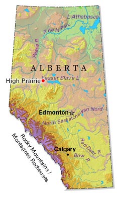
High Prairie, Alta, incorporated as a village in 1945 and as a town in 1950, population 2600 (2011c), 2785 (2006c). Located on the south edge of the Peace River region, the Town of High Prairie is 365 km northwest of Edmonton and 200 km northeast of Grande Prairie.
"https://d2ttikhf7xbzbs.cloudfront.net/media/media/430178ab-66e7-4f64-a004-dcce0b8ac820.jpg" // resources/views/front/categories/view.blade.php
https://d2ttikhf7xbzbs.cloudfront.net/media/media/430178ab-66e7-4f64-a004-dcce0b8ac820.jpg
-
Article
Motor Vehicle Disasters in Canada
Numerous tragedies have unfolded on Canadian roads and highways, the deadliest being a bus crash that killed 44 people in Quebec in 1997. Despite the death toll in such headline-grabbing disasters, Canada’s motor vehicle fatality and injury rates are steadily declining, thanks to engineering improvements in vehicles, and the increasing promotion and awareness of safe driving practices.
"https://d2ttikhf7xbzbs.cloudfront.net/media/Twitter_Cards/humboldt-1.png" // resources/views/front/categories/view.blade.php
https://d2ttikhf7xbzbs.cloudfront.net/media/Twitter_Cards/humboldt-1.png
-
Article
Hillsborough River
The Hillsborough River begins near the white sand beaches of the north shore and winds 45 km through rich farm country to its mouth (Charlottetown Harbour) on the south shore of Prince Edward Island. At its mouth, the North and West rivers come together to meet the Hillsborough.
"https://development.thecanadianencyclopedia.ca/images/tce_placeholder.jpg?v=e9dca980c9bdb3aa11e832e7ea94f5d9" // resources/views/front/categories/view.blade.php
https://development.thecanadianencyclopedia.ca/images/tce_placeholder.jpg?v=e9dca980c9bdb3aa11e832e7ea94f5d9
-
"https://development.thecanadianencyclopedia.ca/images/tce_placeholder.jpg?v=e9dca980c9bdb3aa11e832e7ea94f5d9" // resources/views/front/categories/view.blade.php
https://development.thecanadianencyclopedia.ca/images/tce_placeholder.jpg?v=e9dca980c9bdb3aa11e832e7ea94f5d9
-
Article
Historic Dunvegan
One of the most important fur trade sites on the PEACE RIVER, a post operated at Dunvegan from 1805 to 1918. The first post was built by Archibald Norman McLeod of the North West Company to trade with the BEAVER and other First Nations who lived in the middle and upper reaches of the Peace River.
"https://d2ttikhf7xbzbs.cloudfront.net/media/media/1b7019ae-3e5d-4d8a-9491-35e2fb72ca9a.jpg" // resources/views/front/categories/view.blade.php
https://d2ttikhf7xbzbs.cloudfront.net/media/media/1b7019ae-3e5d-4d8a-9491-35e2fb72ca9a.jpg
-
Article
Historic Sites in Canada
Historic sites are places that are recognized for their importance in Canadian history. Provincial or territorial historic sites are designated by provincial and territorial governments, while national historic sites are designated by the federal government. At the federal level, the Historic Sites and Monuments Board of Canada also designates people and events of national significance, in addition to sites. These people and events are often commemorated by a plaque at a physical place. Municipalities also often have the authority to designate historic sites of local significance, as do Indigenous organizations under self-government agreements. Finally, historic sites may be designated at more than one level (e.g., provincial and national). (See also National Historic Sites in Canada; UNESCO World Heritage Sites in Canada).
"https://d2ttikhf7xbzbs.cloudfront.net/media/new_article_images/WritingOnStoneProvincialPark/48208326871_e9ef42fa43_h.jpg" // resources/views/front/categories/view.blade.php
https://d2ttikhf7xbzbs.cloudfront.net/media/new_article_images/WritingOnStoneProvincialPark/48208326871_e9ef42fa43_h.jpg
