Browse "Places"
-
Article
Hudson
This wealthy residential suburb of Montréal is proud of its stately homes, and its residents also highly value a great variety of sports and cultural activities. The town's economy lacks an industrial base.
"https://d2ttikhf7xbzbs.cloudfront.net/media/media/138d11c8-39df-4cf2-9c45-897962add14b.jpg" // resources/views/front/categories/view.blade.php
https://d2ttikhf7xbzbs.cloudfront.net/media/media/138d11c8-39df-4cf2-9c45-897962add14b.jpg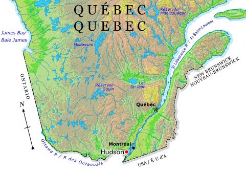
-
Article
Hudson Bay
It is virtually landlocked but is joined to the Arctic Ocean to the north by Foxe Channel and Fury and Hecla Strait, and to the Atlantic Ocean on the east by Hudson Strait. Baffin Island lies athwart the entrance to the bay, and Southampton, Coats and Mansel islands are lodged across the northern gap.
"https://d2ttikhf7xbzbs.cloudfront.net/media/media/dc17d99c-a66e-4177-b23e-edb98803236c.jpg" // resources/views/front/categories/view.blade.php
https://d2ttikhf7xbzbs.cloudfront.net/media/media/dc17d99c-a66e-4177-b23e-edb98803236c.jpg
-
Article
Hudson Bay Railway
The idea of the Hudson Bay Railway, which eventually came to run from Winnipeg to The Pas, and then to Churchill, Manitoba, was conceived by public and private interests in the late 19th century as a means of transporting grain as quickly as possible onto ships for overseas sale. Over a period of almost 50 years, construction efforts ran into various problems — including engineering disputes, storms, a harsh northern climate, fires, labour unrest, and material and labour shortages. From 1910 onwards, the federal government took charge of paying for the engineering and construction work for the railway line, particularly after the creation of Canadian National Railways in 1919. The line was completed in 1929 and opened for full service in 1931. (See also Railway History in Canada.)
"https://d2ttikhf7xbzbs.cloudfront.net/hudsonbayrailway/engine2735.jpg" // resources/views/front/categories/view.blade.php
https://d2ttikhf7xbzbs.cloudfront.net/hudsonbayrailway/engine2735.jpg
-
Article
Hudson Bay (Sask)
By the end of WWII the community had grown sufficiently to obtain town status, a fact emphasized by dropping "Junction" from its name (1947). Since then, while growth has continued, the economy has been modified.
"https://development.thecanadianencyclopedia.ca/images/tce_placeholder.jpg?v=e9dca980c9bdb3aa11e832e7ea94f5d9" // resources/views/front/categories/view.blade.php
https://development.thecanadianencyclopedia.ca/images/tce_placeholder.jpg?v=e9dca980c9bdb3aa11e832e7ea94f5d9
-
Article
Hudson Strait
Hudson Strait is an arm of the sea connecting the Atlantic Ocean with Hudson Bay and Foxe Channel and separating Baffin Island from the Ungava Peninsula of Québec. The eastern gap is between Cape Chidley, at the northern tip of Labrador, and Resolution Island.
"https://development.thecanadianencyclopedia.ca/images/tce_placeholder.jpg?v=e9dca980c9bdb3aa11e832e7ea94f5d9" // resources/views/front/categories/view.blade.php
https://development.thecanadianencyclopedia.ca/images/tce_placeholder.jpg?v=e9dca980c9bdb3aa11e832e7ea94f5d9
-
Article
Hull
Hull, Quebec, is part of the city of Gatineau. Originally its own municipality, Hull amalgamated with the municipalities of Aylmer, Buckingham, Gatineau and Masson-Angers in 2002. When Hull was incorporated in 1875, it was named after the township in which it was situated. In turn, Hull Township got its name from the city of Hull in Yorkshire, England.
"https://d2ttikhf7xbzbs.cloudfront.net/media/media/803bc157-04ec-48c6-8f84-23149e23faad.jpg" // resources/views/front/categories/view.blade.php
https://d2ttikhf7xbzbs.cloudfront.net/media/media/803bc157-04ec-48c6-8f84-23149e23faad.jpg
-
Article
Human Geography and Canada
Human geography studies the relationships between people and the environments in which they live. Within the field of human geography there are five main areas of study. These areas are economic geography, cultural geography, political geography, urban geography and environmental geography. In Canada, human geographers might study the status of Indigenous languages or differences between rural and urban Canadians, among many other topics.
"https://d2ttikhf7xbzbs.cloudfront.net/media/new_article_images/HumanGeography/TCEpopulation_map.jpg" // resources/views/front/categories/view.blade.php
https://d2ttikhf7xbzbs.cloudfront.net/media/new_article_images/HumanGeography/TCEpopulation_map.jpg
-
Article
Human Settlement in Canada
A human settlement is a place where people live. Settlement patterns describe the ways in which villages, towns, cities and First Nation reserves are distributed, as well as the factors that influence this arrangement. Throughout Canadian history, climate, natural resources, transportation methods and government policy have affected human settlement in the country. Today, the majority of Canadians live in cities in the southern portion of the country. (See also Human Geography and Canada.)
"https://d2ttikhf7xbzbs.cloudfront.net/media/new_article_images/HumanSettlement/PopDensityMap2019_EN.png" // resources/views/front/categories/view.blade.php
https://d2ttikhf7xbzbs.cloudfront.net/media/new_article_images/HumanSettlement/PopDensityMap2019_EN.png
-
Article
Humber River (Newfoundland)
The Humber River, 153 km long, drainage basin 7680 km2, is the principal river of western Newfoundland.
"https://development.thecanadianencyclopedia.ca/images/tce_placeholder.jpg?v=e9dca980c9bdb3aa11e832e7ea94f5d9" // resources/views/front/categories/view.blade.php
https://development.thecanadianencyclopedia.ca/images/tce_placeholder.jpg?v=e9dca980c9bdb3aa11e832e7ea94f5d9
-
Article
Humber River (Ontario)
Encompassing 908 km2 in total, the Humber River watershed is the largest in the Toronto region. The 126-kilometre long Humber River has its headwaters in the ancient rock of the NIAGARA ESCARPMENT and the glacial hills of the Oak Ridges Moraine.
"https://development.thecanadianencyclopedia.ca/images/tce_placeholder.jpg?v=e9dca980c9bdb3aa11e832e7ea94f5d9" // resources/views/front/categories/view.blade.php
https://development.thecanadianencyclopedia.ca/images/tce_placeholder.jpg?v=e9dca980c9bdb3aa11e832e7ea94f5d9
-
Article
Humboldt
Its designation as a railway divisional point fostered growth, as did the establishment of St Peters Colony (50 townships) by the Roman Catholic Order of St Benedict (1903).
"https://development.thecanadianencyclopedia.ca/images/tce_placeholder.jpg?v=e9dca980c9bdb3aa11e832e7ea94f5d9" // resources/views/front/categories/view.blade.php
https://development.thecanadianencyclopedia.ca/images/tce_placeholder.jpg?v=e9dca980c9bdb3aa11e832e7ea94f5d9
-
Article
Huntsville
Huntsville, Ont, incorporated as a town in 1900, population 19 056 (2011c), 18 280 (2006c). The Town of Huntsville is located 215 km north of Toronto on a short section of the Muskoka River connecting Vernon and Fairy lakes.
"https://d2ttikhf7xbzbs.cloudfront.net/media/media/d0fdd9f6-db3d-4408-99a3-2c5eb442fbea.jpg" // resources/views/front/categories/view.blade.php
https://d2ttikhf7xbzbs.cloudfront.net/media/media/d0fdd9f6-db3d-4408-99a3-2c5eb442fbea.jpg
-
Article
Huron Brant
Huron Eldon Brant, Mohawk soldier, war hero, automobile mechanic (born 30 December 1909 in Deseronto, ON; died 14 October 1944 near Bulgaria, Italy). Brant was awarded the Military Medal (MM) for attacking a superior enemy force during the battle for Grammichele in Sicily (seeSecond World War) but was killed later during a battle on the Italian mainland (see The Italian Campaign).
"https://d2ttikhf7xbzbs.cloudfront.net/media/new_article_images/HuronBrant/Huron_Brant_image.jpg" // resources/views/front/categories/view.blade.php
https://d2ttikhf7xbzbs.cloudfront.net/media/new_article_images/HuronBrant/Huron_Brant_image.jpg
-
Article
Wendake (Huronia)
Wendake is a Huron-Wendat settlement dating back to the 17th century, once known by various names including “Huronia,” "the country of the Huron" or “the Huron village.” Today, Wendake refers to the urban reserve of the Huron-Wendat Nation, located near Quebec City, Quebec.
"https://d2ttikhf7xbzbs.cloudfront.net/media/media/dbcf9b74-90d5-42a2-8f3c-9e38996ea0b7.jpg" // resources/views/front/categories/view.blade.php
https://d2ttikhf7xbzbs.cloudfront.net/media/media/dbcf9b74-90d5-42a2-8f3c-9e38996ea0b7.jpg
-
Article
Iberville
Visitors are attracted by Iberville's impressive Roman Catholic church, local vineyards and picturesque riverside setting. Iberville and the surrounding region were hard hit by the January 1998 ice storm that slashed across eastern Ontario and southern Québec.
"https://d2ttikhf7xbzbs.cloudfront.net/media/media/6ecaaa8b-d704-4641-98f4-e22db45e4668.jpg" // resources/views/front/categories/view.blade.php
https://d2ttikhf7xbzbs.cloudfront.net/media/media/6ecaaa8b-d704-4641-98f4-e22db45e4668.jpg