Browse "Places"
-
Macleans
Iqaluit: Future Capital
Adapting. It's a buzzword among the Inuit, and for good reason.This article was originally published in Maclean's Magazine on February 19, 1996
"https://d2ttikhf7xbzbs.cloudfront.net/media/media/af7269d4-d65f-451f-af70-3e54fcb8a8f1.jpg" // resources/views/front/categories/view.blade.php
https://d2ttikhf7xbzbs.cloudfront.net/media/media/af7269d4-d65f-451f-af70-3e54fcb8a8f1.jpg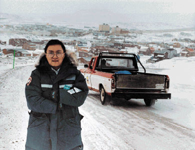
-
Article
Irishtown-Summerside
Irishtown-Summerside, NL, incorporated as a town in 1991, population 1428 (2011c), 1290 (2006c). Irishtown-Summerside is located on Humber Arm in the Bay of Islands near Corner Brook.
"https://development.thecanadianencyclopedia.ca/images/tce_placeholder.jpg?v=e9dca980c9bdb3aa11e832e7ea94f5d9" // resources/views/front/categories/view.blade.php
https://development.thecanadianencyclopedia.ca/images/tce_placeholder.jpg?v=e9dca980c9bdb3aa11e832e7ea94f5d9
-
Article
Iroquois Falls
Iroquois Falls, Ont, Town, incorporated as a town in 1915, population 4595 (2011c), 4729 (2006c). The Town of Iroquois Falls is located 334 km northwest of North Bay.
"https://development.thecanadianencyclopedia.ca/images/tce_placeholder.jpg?v=e9dca980c9bdb3aa11e832e7ea94f5d9" // resources/views/front/categories/view.blade.php
https://development.thecanadianencyclopedia.ca/images/tce_placeholder.jpg?v=e9dca980c9bdb3aa11e832e7ea94f5d9
-
Article
Island
The total number of islands in Canada has never been established, but it is very large. It is estimated that there are some 30 000 islands along the eastern shore of GEORGIAN BAY alone (the Thirty Thousand Islands).
"https://d2ttikhf7xbzbs.cloudfront.net/media/media/79d1e122-c898-4f67-8500-8c2d799e7700.jpg" // resources/views/front/categories/view.blade.php
https://d2ttikhf7xbzbs.cloudfront.net/media/media/79d1e122-c898-4f67-8500-8c2d799e7700.jpg
-
Article
Ivvavik National Park
High mountains, broad river valleys, endless tundra, and the Arctic seacoast come together within Ivvavik National Park (est 1984, 9750 km2) to create a wilderness paradise. Located about 800 km northwest of Whitehorse, YT, or 200 km west of Inuvik, NWT, it is just about as far away as you can get from anywhere. Access is usually by charter aircraft from Inuvik. Initially known as Northern Yukon National Park, it was given an Inuvialuit name in 1992. Ivvavik means "place of giving birth and raising young" in reference to the Porcupine Caribou herd that has its calving grounds along the Beaufort Sea coast. It is Canada's first park established through a native land claim settlement. Due to its isolation, it is one of the least visited national parks in Canada.
"https://d2ttikhf7xbzbs.cloudfront.net/media/media/ba702448-1511-48f9-b516-fe8723fbb166.jpg" // resources/views/front/categories/view.blade.php
https://d2ttikhf7xbzbs.cloudfront.net/media/media/ba702448-1511-48f9-b516-fe8723fbb166.jpg
-
Article
Jaffray Melick
Jaffray Melick, Ont, was a town from 1988 to 2000. Its former territory is now the easternmost section of the city of KENORA.
"https://d2ttikhf7xbzbs.cloudfront.net/media/media/1bf03a7f-ee0f-4f62-bd82-e4196d3f3040.jpg" // resources/views/front/categories/view.blade.php
https://d2ttikhf7xbzbs.cloudfront.net/media/media/1bf03a7f-ee0f-4f62-bd82-e4196d3f3040.jpg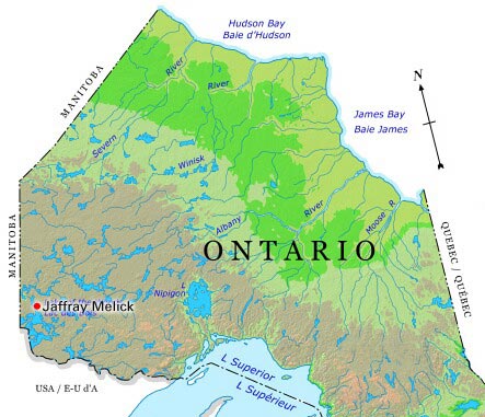
-
Article
James Bay
James Bay is the southern appendage of Hudson Bay. It is about 160 km wide between Pointe Louis-XIV on the east coast and Cape Henrietta Marie on the west.
"https://development.thecanadianencyclopedia.ca/images/tce_placeholder.jpg?v=e9dca980c9bdb3aa11e832e7ea94f5d9" // resources/views/front/categories/view.blade.php
https://development.thecanadianencyclopedia.ca/images/tce_placeholder.jpg?v=e9dca980c9bdb3aa11e832e7ea94f5d9
-
Article
Jasper
Jasper, Alta, incorporated as a specialized municipality in 2001, population 4051 (2011c), 4265 (2006c). The Municipality of Jasper is located at the junction of the Miette and Athabasca rivers in JASPER NATIONAL PARK, 362 km west of Edmonton.
"https://d2ttikhf7xbzbs.cloudfront.net/media/media/c315e3ee-1e50-4979-8262-d18cb2844c6e.jpg" // resources/views/front/categories/view.blade.php
https://d2ttikhf7xbzbs.cloudfront.net/media/media/c315e3ee-1e50-4979-8262-d18cb2844c6e.jpg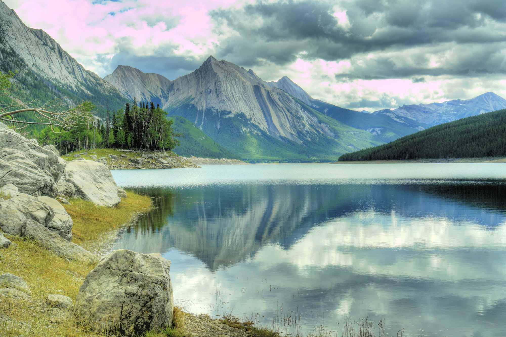
-
Article
Jasper National Park
Jasper National Park is a protected area located in the Rocky Mountains, about 370 km west of Edmonton, Alberta. Established in 1907, it was the fifth national park created in Canada. It’s also one of seven parks in the Rocky Mountains that make up the Canadian Rocky Mountain Parks UNESCO World Heritage site (the others are Yoho, Banff and Kootenay national parks, and Mount Robson, Mount Assiniboine and Hamber provincial parks). Among the reasons for the UNESCO designation are the parks’ mountain landscapes, complete with waterfalls, canyons and glaciers, including those found in the Columbia Icefield.
"https://d2ttikhf7xbzbs.cloudfront.net/media/Twitter_Cards/jasper.jpg" // resources/views/front/categories/view.blade.php
https://d2ttikhf7xbzbs.cloudfront.net/media/Twitter_Cards/jasper.jpg
-
Article
Jazz City
Jazz City (formally, Jazz City International Jazz Festival 1980-90, du Maurier Ltd Jazz City, as of 1991). It was established by the Edmonton Jazz Society in 1980 under the direction of Marc Vasey in response to an initiative from Alberta Culture on the occasion of the province's 75th anniversary.
"https://development.thecanadianencyclopedia.ca/images/tce_placeholder.jpg?v=e9dca980c9bdb3aa11e832e7ea94f5d9" // resources/views/front/categories/view.blade.php
https://development.thecanadianencyclopedia.ca/images/tce_placeholder.jpg?v=e9dca980c9bdb3aa11e832e7ea94f5d9
-
Article
Jemseg Archaeological Site
The Jemseg archaeological site (Borden site designation number BkDm-14) is a major archaeological site located in south-central New Brunswick, on the stream that connects the Grand Lake system to the lower Saint John River.
"https://d2ttikhf7xbzbs.cloudfront.net/media/media/a7ddfad9-aa2e-425b-b65a-3fbd6a372095.jpg" // resources/views/front/categories/view.blade.php
https://d2ttikhf7xbzbs.cloudfront.net/media/media/a7ddfad9-aa2e-425b-b65a-3fbd6a372095.jpg
-
Article
Joggins Fossil Cliffs
The Joggins Fossil Cliffs are located in Nova Scotia, on the shores of Cumberland Basin in the upper Bay of Fundy. They contain an exceptional fossil record of the carboniferous period. In 2008, these cliffs were designated a UNESCO World Heritage Site.
"https://development.thecanadianencyclopedia.ca/images/tce_placeholder.jpg?v=e9dca980c9bdb3aa11e832e7ea94f5d9" // resources/views/front/categories/view.blade.php
https://development.thecanadianencyclopedia.ca/images/tce_placeholder.jpg?v=e9dca980c9bdb3aa11e832e7ea94f5d9
-
Article
Joliette
It was founded about 1824 by Barthélemy Joliette, seigneur de Lavaltrie, who wanted to become involved in the forestry industry. The lumber mill was one of the first buildings constructed. The town's economy diversified rapidly with the establishment of stone quarries and a foundry.
"https://development.thecanadianencyclopedia.ca/images/tce_placeholder.jpg?v=e9dca980c9bdb3aa11e832e7ea94f5d9" // resources/views/front/categories/view.blade.php
https://development.thecanadianencyclopedia.ca/images/tce_placeholder.jpg?v=e9dca980c9bdb3aa11e832e7ea94f5d9
-
Article
Music in Joliette
City situated 75 kilometres to the north-east of Montreal, incorporated on 18 October 1863. In 1991, Joliette had a population of about 31,000 inhabitants.
"https://development.thecanadianencyclopedia.ca/images/tce_placeholder.jpg?v=e9dca980c9bdb3aa11e832e7ea94f5d9" // resources/views/front/categories/view.blade.php
https://development.thecanadianencyclopedia.ca/images/tce_placeholder.jpg?v=e9dca980c9bdb3aa11e832e7ea94f5d9
-
Article
Jonquière
As the industrial axis of the region, its history is closely tied to the history of major corporations, specifically to that of the Price Company Ltd (now Abitibi-Price Inc) and Alcan. An agricultural parish founded in 1847, Jonquière began developing after 1893 when the railway arrived.
"https://d2ttikhf7xbzbs.cloudfront.net/media/media/21c5573a-de65-429a-b557-c72d0572f3dc.jpg" // resources/views/front/categories/view.blade.php
https://d2ttikhf7xbzbs.cloudfront.net/media/media/21c5573a-de65-429a-b557-c72d0572f3dc.jpg