Browse "Places"
-
Article
Library of Parliament
The Library of Parliament came into being when the legislative libraries of Upper and Lower Canada were amalgamated in 1841 and situated in Montréal. In 1849 only 200 of the 12,000 books were saved when an angry mob protesting the Rebellion Losses Bill set fire to the Parliament Buildings.
"https://d2ttikhf7xbzbs.cloudfront.net/media/media/0a4e70e6-7f91-4f8f-8d9a-ac741765b114.jpg" // resources/views/front/categories/view.blade.php
https://d2ttikhf7xbzbs.cloudfront.net/media/media/0a4e70e6-7f91-4f8f-8d9a-ac741765b114.jpg
-
Article
Lighthouses in Canada
Canada’s massive coastline and 2 million lakes have a rich history of lighthouses, and many continue to stand to this day. Lighthouses and long-range lights have served as navigational beacons, helping keep vessels safe for centuries. While many continue to serve as navigational aids, many lighthouses in Canada are now heritage sites protected by parks and communities.
"https://d2ttikhf7xbzbs.cloudfront.net/media/media/92b59d7f-573e-494e-9957-85572b17acf0.jpg" // resources/views/front/categories/view.blade.php
https://d2ttikhf7xbzbs.cloudfront.net/media/media/92b59d7f-573e-494e-9957-85572b17acf0.jpg
-
Article
L'Île-Perrot
First set up as the parish municipality of Sainte-Jeanne-Chantal-de-l'Isle-Perrot in 1855, the name was changed to L'Île-Perrot in 1946.
"https://d2ttikhf7xbzbs.cloudfront.net/media/media/3ebf671c-e611-47b8-b744-cb14e68e285a.jpg" // resources/views/front/categories/view.blade.php
https://d2ttikhf7xbzbs.cloudfront.net/media/media/3ebf671c-e611-47b8-b744-cb14e68e285a.jpg
-
Article
Lillian Elias
Lillian Elias (whose Inuvialuktun name is Panigavluk), ONWT, teacher, language activist (born 1943 in the Mackenzie Delta, NT). Influenced by her time at residential school, where administrators attempted to forcefully strip her of her language and culture, Lillian Elias has spent much of her life promoting and preserving her first language, Inuvialuktun (see Inuvialuit).
"https://d2ttikhf7xbzbs.cloudfront.net/LillianElias/Lillian-Elias_Screencap_Tweetonly.jpg" // resources/views/front/categories/view.blade.php
https://d2ttikhf7xbzbs.cloudfront.net/LillianElias/Lillian-Elias_Screencap_Tweetonly.jpg
-
Article
Lillooet
Lillooet, BC, incorporated as a district municipality in 1996, population 2322 (2011c), 2324 (2006c). The District of Lillooet is located in the southern interior of British Columbia, 252 km northeast of Vancouver.
"https://development.thecanadianencyclopedia.ca/images/tce_placeholder.jpg?v=e9dca980c9bdb3aa11e832e7ea94f5d9" // resources/views/front/categories/view.blade.php
https://development.thecanadianencyclopedia.ca/images/tce_placeholder.jpg?v=e9dca980c9bdb3aa11e832e7ea94f5d9
-
Article
Lincoln
Lincoln, Ont, incorporated as a town in 1970, population 22 487 (2011c), 21 722 (2006c). The Town of Lincoln is situated in the Niagara Peninsula, immediately west of ST CATHARINES.
"https://development.thecanadianencyclopedia.ca/images/tce_placeholder.jpg?v=e9dca980c9bdb3aa11e832e7ea94f5d9" // resources/views/front/categories/view.blade.php
https://development.thecanadianencyclopedia.ca/images/tce_placeholder.jpg?v=e9dca980c9bdb3aa11e832e7ea94f5d9
-
Article
Linear Mounds Archaeological Site
Linear Mounds Site, including the Linear Mounds National Historic Site of Canada, is located on the plain overlooking the Souris River in southwestern Manitoba.
"https://d2ttikhf7xbzbs.cloudfront.net/media/media/69b4fffb-a883-442d-beeb-f533063ac2a4.jpg" // resources/views/front/categories/view.blade.php
https://d2ttikhf7xbzbs.cloudfront.net/media/media/69b4fffb-a883-442d-beeb-f533063ac2a4.jpg
-
Article
Lions Gate Bridge
Lions Gate Bridge, which officially opened on 29 May 1939, spans Burrard Inlet at the First Narrows, connecting Stanley Park and Vancouver’s city centre to the North Shore.
"https://d2ttikhf7xbzbs.cloudfront.net/media/media/f3a1aab8-0bf8-48ec-bd53-f9595750a66d.jpg" // resources/views/front/categories/view.blade.php
https://d2ttikhf7xbzbs.cloudfront.net/media/media/f3a1aab8-0bf8-48ec-bd53-f9595750a66d.jpg
-
Article
L'Islet
L'Islet L'Islet, Qué, Municipality, pop 3866 (2001c), 3878 A (1996c), area 120.02 km2, on the South Shore of the ST LAWRENCE RIVER, 100 km east of Québec City, within the former seigneuries of L'Islet-St-Jean and Bonsecours (granted 1677). Before the arrival of the first resident parish priest in 1745, L'Islet was served by missionary priests, and the parish of Notre-Dame-de-Bon-Secours-de-L'Islet was founded in 1721. Until the end of the 19th century, agriculture was the principal...
"https://development.thecanadianencyclopedia.ca/images/tce_placeholder.jpg?v=e9dca980c9bdb3aa11e832e7ea94f5d9" // resources/views/front/categories/view.blade.php
https://development.thecanadianencyclopedia.ca/images/tce_placeholder.jpg?v=e9dca980c9bdb3aa11e832e7ea94f5d9
-
Article
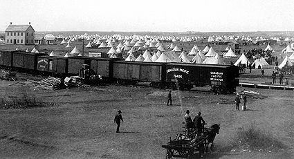
Listowel
Listowel, ON, incorporated in 1867 as a village and in 1875 as a town, population 9,539 (2021 census), 7,530 (2016 census). Listowel is now part of the town of North Perth (incorporated in 1998). It is located 66 km northwest of Kitchener - Waterloo.
"https://d2ttikhf7xbzbs.cloudfront.net/media/media/1490e962-ca51-42d8-8293-de7ed1462d21.jpg" // resources/views/front/categories/view.blade.php
https://d2ttikhf7xbzbs.cloudfront.net/media/media/1490e962-ca51-42d8-8293-de7ed1462d21.jpg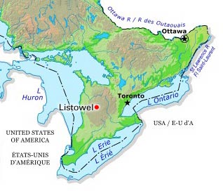
-
Article
Listuguj
Listuguj, Quebec, is the common name for both a reserve and a Mi'kmaq First Nation. Listuguj is located on the Gaspé Peninsula at the mouth of Restigouche River. A bridge links it to Campbellton, New Brunswick. As of 2014, the Listuguj First Nation has 4,058 members, with 2,108 members living on the Listuguj reserve. The community was also previously known as Restigouche.
"https://development.thecanadianencyclopedia.ca/images/tce_placeholder.jpg?v=e9dca980c9bdb3aa11e832e7ea94f5d9" // resources/views/front/categories/view.blade.php
https://development.thecanadianencyclopedia.ca/images/tce_placeholder.jpg?v=e9dca980c9bdb3aa11e832e7ea94f5d9
-
Article
Little Burgundy and Montreal's Black English-Speaking Community
Little Burgundy is a neighbourhood in the southwest borough of Montreal, Quebec. It is the historical home of the city’s Black English-speaking, working-class community (see also Black Canadians). Montreal's early Black settlement was comprised mainly of African Americans who lived in the Faubourg (French for "suburb") of St. Antoine — a neighbourhood that is now known as Little Burgundy. The settlement dates to the emergence of the railway companies in the mid- to late 19th century and the era of the Black sleeping car porters.
"https://d2ttikhf7xbzbs.cloudfront.net/media/Twitter_Cards/Rockhead's Paradise.png" // resources/views/front/categories/view.blade.php
https://d2ttikhf7xbzbs.cloudfront.net/media/Twitter_Cards/Rockhead's Paradise.png
-
Article
Little Manitou Lake
Little Manitou Lake, 13.3 km2, is a saline lake that lies in the rich, rolling prairie of south-central Saskatchewan near Watrous.
"https://development.thecanadianencyclopedia.ca/images/tce_placeholder.jpg?v=e9dca980c9bdb3aa11e832e7ea94f5d9" // resources/views/front/categories/view.blade.php
https://development.thecanadianencyclopedia.ca/images/tce_placeholder.jpg?v=e9dca980c9bdb3aa11e832e7ea94f5d9
-
Article
Living Shorelines
Living shorelines, also known as green shorelines, are a form of environmental soft engineering designed to reduce coastal erosion and protect waterfront properties. By planting native grasses, shrubs and other vegetation along the coastline, which act as a natural barrier against harsh waves and storms, living shorelines can absorb the impact and direct it away from eroding soil. In doing so, they also create suitable habitats for birds and various aquatic species. In many cases, they are a viable replacement for hard engineering erosion prevention like seawalls and rip-raps, which can damage the coastline and surrounding ecosystem. In other cases, living shorelines combine hard and soft engineering to better protect against intense climates. With so much versatility in terms of appearance and approach, it can be difficult to define what a true living shoreline looks like. This green infrastructure can be found along the Atlantic and Pacific coasts of Canada.
"https://d2ttikhf7xbzbs.cloudfront.net/livingshorelines/Living-Shoreline-After.jpg" // resources/views/front/categories/view.blade.php
https://d2ttikhf7xbzbs.cloudfront.net/livingshorelines/Living-Shoreline-After.jpg
-
Article
Lloydminster
Lloydminster, Alberta and Saskatchewan, incorporated as a city in 1958, population 19,739 in Alberta and 11,843 in Saskatchewan (2021 census); 19,645 in Alberta and 11,765 in Saskatchewan (2016 census). The city of Lloydminster is known as the “Border City” since it is located on the Saskatchewan-Alberta border, about 275 km west of Saskatoon and 250 km east of Edmonton. It is one of two communities in Canada split by a provincial boundary, the other being Flin Flon, Manitoba.
"https://d2ttikhf7xbzbs.cloudfront.net/media/media/94afb778-e678-4eb6-999e-e723944f1edd.jpg" // resources/views/front/categories/view.blade.php
https://d2ttikhf7xbzbs.cloudfront.net/media/media/94afb778-e678-4eb6-999e-e723944f1edd.jpg