Browse "Places"
-
Article
Port Alberni
Port Alberni, BC, incorporated as a city in 1967, population 17,678 (2016 c), 17,743 (2011 c). The present-day City of Port Alberni is the result of the 1967 amalgamation of two cities, Port Alberni (incorporated in 1912) and Alberni (incorporated in 1913). Port Alberni is located on central Vancouver Island, 195 km north of Victoria, at the head of Alberni Inlet, a deep fjord-like inlet that almost divides the island in two. The inlet was named after Don Pedro de Alberni, the Spanish officer in command of the Nootka garrison in 1791 during the Spanish occupation. In 1964, a tsunami caused by the Good Friday earthquake in Alaska moved up the inlet and hit the twin cities. About 375 houses were damaged, 55 of which were washed away, but there were no casualties.
"https://d2ttikhf7xbzbs.cloudfront.net/media/media/a4a66b07-c602-42f7-a156-77ed5d1334ff.jpg" // resources/views/front/categories/view.blade.php
https://d2ttikhf7xbzbs.cloudfront.net/media/media/a4a66b07-c602-42f7-a156-77ed5d1334ff.jpg
-
Article
Port au Choix
Port au Choix, NL, incorporated as a town in 1966, population 839 (2011c), 893 (2006c). The Town of Port au Choix is located on the west side of the Northern Peninsula.
"https://d2ttikhf7xbzbs.cloudfront.net/media/media/e18c8b0a-0307-4e37-b091-5665412f4aa5.jpg" // resources/views/front/categories/view.blade.php
https://d2ttikhf7xbzbs.cloudfront.net/media/media/e18c8b0a-0307-4e37-b091-5665412f4aa5.jpg
-
Article
Port-au-Port Peninsula
Port-au-Port peninsula is a roughly triangular peninsula with 130 km of rocky coastline but no harbours. The peninsula is joined to southwestern Newfoundland via a strip of land west of Stephenville. Port-au-Port is home to Newfoundland’s oldest francophone communities (see Francophones of Newfoundland and Labrador).
"https://development.thecanadianencyclopedia.ca/images/tce_placeholder.jpg?v=e9dca980c9bdb3aa11e832e7ea94f5d9" // resources/views/front/categories/view.blade.php
https://development.thecanadianencyclopedia.ca/images/tce_placeholder.jpg?v=e9dca980c9bdb3aa11e832e7ea94f5d9
-
Article
Port Colborne
Port Colborne, Ontario, incorporated as a city in 1966, population 18,306 (2016 census), 18,424 (2011 census). The city of Port Colborne is located on Lake Erie and serves as the south port of entry to the Welland Canal. It was named for Sir John Colborne, a lieutenant-governor of Upper Canada.
"https://development.thecanadianencyclopedia.ca/images/tce_placeholder.jpg?v=e9dca980c9bdb3aa11e832e7ea94f5d9" // resources/views/front/categories/view.blade.php
https://development.thecanadianencyclopedia.ca/images/tce_placeholder.jpg?v=e9dca980c9bdb3aa11e832e7ea94f5d9
-
Article
Port Coquitlam
Port Coquitlam, British Columbia, incorporated as a city in 1913, population 61,498 (2021 census), 58,612 (2016 census). The City of Port Coquitlam is located on the Pitt and Fraser rivers, 27 km east of Vancouver. It is bounded on the north and west by the City of Coquitlam. It is a member of the Metro Vancouver Regional District and part of the Tri-Cities with Coquitlam and Port Moody.
"https://development.thecanadianencyclopedia.ca/images/tce_placeholder.jpg?v=e9dca980c9bdb3aa11e832e7ea94f5d9" // resources/views/front/categories/view.blade.php
https://development.thecanadianencyclopedia.ca/images/tce_placeholder.jpg?v=e9dca980c9bdb3aa11e832e7ea94f5d9
-
Article
Port Edward
Port Edward, BC, incorporated as a district municipality in 1991, population 544 (2011c), 577 (2006c). The District of Port Edward is located near PRINCE RUPERT on British Columbia's northern mainland coast, on Inverness Passage near the mouth of the SKEENA RIVER.
"https://development.thecanadianencyclopedia.ca/images/tce_placeholder.jpg?v=e9dca980c9bdb3aa11e832e7ea94f5d9" // resources/views/front/categories/view.blade.php
https://development.thecanadianencyclopedia.ca/images/tce_placeholder.jpg?v=e9dca980c9bdb3aa11e832e7ea94f5d9
-
Article
Port Elgin
Port Elgin, Ont, urban area, population 9,619 (2021 census), 8,297 (2016 census). Port Elgin is located on the shores of Lake Huron in Bruce County at the mouth of the Saugeen River, 48 km southwest of Owen Sound. A town from 1949 to 1999, it is now the administrative centre of the town of Saugeen Shores, which resulted from the amalgamation of Port Elgin with the town of Southampton and Saugeen Township.
"https://d2ttikhf7xbzbs.cloudfront.net/media/media/c954a74f-0922-4f98-9f82-90a754c95720.jpg" // resources/views/front/categories/view.blade.php
https://d2ttikhf7xbzbs.cloudfront.net/media/media/c954a74f-0922-4f98-9f82-90a754c95720.jpg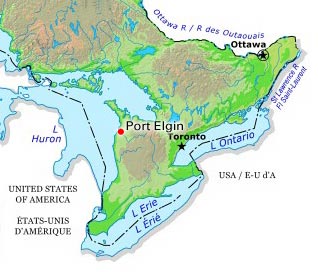
-
Article
Port Hardy
Port Hardy, BC, incorporated as a district municipality in 1966, population 4008 (2011c), 3822 (2006c). The District of Port Hardy is located on the northeast coast of VANCOUVER ISLAND, 391 km by road north of NANAIMO.
"https://development.thecanadianencyclopedia.ca/images/tce_placeholder.jpg?v=e9dca980c9bdb3aa11e832e7ea94f5d9" // resources/views/front/categories/view.blade.php
https://development.thecanadianencyclopedia.ca/images/tce_placeholder.jpg?v=e9dca980c9bdb3aa11e832e7ea94f5d9
-
Article
Port Hawkesbury
Some farming and a local forest industry supported the livelihood of the dominant Scottish population. As an early 19th-century ferry terminus and later a railway centre, the town suffered the loss of these activities from the building of the Canso Causeway in the mid-1950s at nearby Port Hastings.
"https://development.thecanadianencyclopedia.ca/images/tce_placeholder.jpg?v=e9dca980c9bdb3aa11e832e7ea94f5d9" // resources/views/front/categories/view.blade.php
https://development.thecanadianencyclopedia.ca/images/tce_placeholder.jpg?v=e9dca980c9bdb3aa11e832e7ea94f5d9
-
Article
Port Hope
Long a manufacturing and regional commercial centre, Port Hope's main street is one of the best preserved from late 19th-century Ontario. It is now a centre for uranium refining and the manufacture of machinery, tools, plastics and rubber.
"https://development.thecanadianencyclopedia.ca/images/tce_placeholder.jpg?v=e9dca980c9bdb3aa11e832e7ea94f5d9" // resources/views/front/categories/view.blade.php
https://development.thecanadianencyclopedia.ca/images/tce_placeholder.jpg?v=e9dca980c9bdb3aa11e832e7ea94f5d9
-
Article
Port McNeill
Port McNeill, BC, incorporated as a town in 1984, population 2505 (2011c), 2623 (2006c). The Town of Port McNeill is located on the northeast coast of VANCOUVER ISLAND on Broughton Strait, 200 km northwest of CAMPBELL RIVER.
"https://d2ttikhf7xbzbs.cloudfront.net/media/media/af04bfbb-be18-40ef-869d-accbd98f0e3a.jpg" // resources/views/front/categories/view.blade.php
https://d2ttikhf7xbzbs.cloudfront.net/media/media/af04bfbb-be18-40ef-869d-accbd98f0e3a.jpg
-
Article
Port Moody
Port Moody, British Columbia, incorporated as a city in 1913, population 33,535 (2021 census), 33,551 (2016 census). The City of Port Moody lies at the head of Burrard Inlet, 20 km east of Vancouver. It is a member of the Metro Vancouver Regional District and part of the Tri-Cities with Coquitlam and Port Coquitlam.
"https://development.thecanadianencyclopedia.ca/images/tce_placeholder.jpg?v=e9dca980c9bdb3aa11e832e7ea94f5d9" // resources/views/front/categories/view.blade.php
https://development.thecanadianencyclopedia.ca/images/tce_placeholder.jpg?v=e9dca980c9bdb3aa11e832e7ea94f5d9
-
Article
Port of Quebec
Throughout its history, the Port of Quebec has undergone numerous changes reflecting the needs and concerns of the day. From its initial military role under the French regime, the Port of Quebec turned to commerce and transformed radically in the 19th century as a result of the timber trade and immigration. These two new realities had major repercussions on the port’s development, which adapted to accommodate ships of increasingly higher tonnage. With its sizable ocean port, the third largest in North America after New York and New Orleans, Quebec became the primary gateway to Canada for hundreds of thousands of immigrants arriving by sea.
"https://d2ttikhf7xbzbs.cloudfront.net/media/new_article_images/portdequebec/1024px-Quebec-Maasdam.JPG" // resources/views/front/categories/view.blade.php
https://d2ttikhf7xbzbs.cloudfront.net/media/new_article_images/portdequebec/1024px-Quebec-Maasdam.JPG
-
Article
Port Refuge
Port Refuge is a small bay on the south coast of Grinnell Peninsula, Devon I, in the high Arctic.
"https://development.thecanadianencyclopedia.ca/images/tce_placeholder.jpg?v=e9dca980c9bdb3aa11e832e7ea94f5d9" // resources/views/front/categories/view.blade.php
https://development.thecanadianencyclopedia.ca/images/tce_placeholder.jpg?v=e9dca980c9bdb3aa11e832e7ea94f5d9
-
Article
Port-Royal National Historic Site
Located in Nova Scotia, Port-Royal National Historic Site features a reconstruction of the Port-Royal Habitation, one of the first settlements attempted by the French in North America (1605). Administered by Parks Canada, this historic site offers interpretive activities that convey the French settlers’ challenges in implementing the new colony. Visitors can also learn about the culture of the Mi’kmaq, the area’s first inhabitants of the land.
"https://d2ttikhf7xbzbs.cloudfront.net/media/media/64771090-5008-4ccf-9621-b6602042e7de.jpg" // resources/views/front/categories/view.blade.php
https://d2ttikhf7xbzbs.cloudfront.net/media/media/64771090-5008-4ccf-9621-b6602042e7de.jpg