Browse "Places"
-
List
Largest Cities in Canada With an Indigenous Name
When naming a village, Canadian settlers looked to a variety of sources. Sometimes they’d name it for a resident or a famous person. Sometimes they’d name it for their hometown. The names of many of Canada’s largest cities, however, are derived from an Indigenous word. Most of the names are descriptive of the land or animals in the area, such as Oshawa and Coquitlam. Others, like Mississauga, are named for the First Nation whose land the city was founded on. In the case of Kelowna, the name began as an offhand joke among Salish friends. Here are the ten most populous cities in Canada with names of Indigenous origin.
"https://d2ttikhf7xbzbs.cloudfront.net/media/new_article_images/LargestCitiesInCanadaWithAnIndigenousName/EmbodyTheSpiritPowwowToronto.jpg" // resources/views/front/categories/view.blade.php
https://d2ttikhf7xbzbs.cloudfront.net/media/new_article_images/LargestCitiesInCanadaWithAnIndigenousName/EmbodyTheSpiritPowwowToronto.jpg
-
List
Largest Lakes in Canada
Surveys suggest that there may be as many as 2 million lakes in Canada. While some look like small scratches on the country’s surface, many are quite large. Nearly fourteen per cent of the world’s lakes with surface areas over 500 km2 are located in Canada. Below is a list of the largest of these large lakes. The list is ordered by the lake’s total surface area, not just the portions within Canadian borders.
"https://d2ttikhf7xbzbs.cloudfront.net/media/media/6250e461-dc90-4c92-a300-ab48c59d20a8.jpg" // resources/views/front/categories/view.blade.php
https://d2ttikhf7xbzbs.cloudfront.net/media/media/6250e461-dc90-4c92-a300-ab48c59d20a8.jpg
-
List
Largest National Parks in Canada
Canada has 48 national parks and national park reserves, as well as one national urban park (see also National Parks of Canada). They protect important land and marine habitats, geographical features and sites of cultural significance. National parks also benefit local economies and the tourism industry in Canada. In total, the parks cover more than 340,000 km2, which is over 3 per cent of Canada’s landmass. Nearly all of Canada’s largest national parks are located in the north, and five of them in Nunavut.
"https://d2ttikhf7xbzbs.cloudfront.net/media/new_article_images/LargestNationalParks/WoodBuffaloNationalPark.jpg" // resources/views/front/categories/view.blade.php
https://d2ttikhf7xbzbs.cloudfront.net/media/new_article_images/LargestNationalParks/WoodBuffaloNationalPark.jpg
-
Article
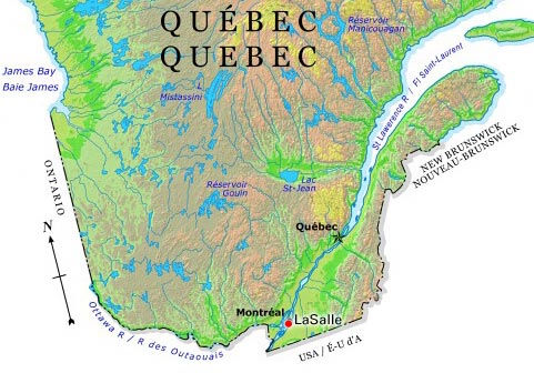
LaSalle
History In 1667, René-Robert Cavelier de la Salle became seigneur of the land of present-day LaSalle. In order to avoid the Lachine Rapids, traders, explorers and Indigenous people portaged along a path that would become LaSalle Boulevard.
"https://d2ttikhf7xbzbs.cloudfront.net/media/media/c26e0d11-ffaa-4f9e-beae-00eff688b6b6.jpg" // resources/views/front/categories/view.blade.php
https://d2ttikhf7xbzbs.cloudfront.net/media/media/c26e0d11-ffaa-4f9e-beae-00eff688b6b6.jpg
-
Article
L'Assomption
L'Assomption, Québec, incorporated as a city in 1992, population 20,065 (2011 c), 16,738 (2006 c).
"https://development.thecanadianencyclopedia.ca/images/tce_placeholder.jpg?v=e9dca980c9bdb3aa11e832e7ea94f5d9" // resources/views/front/categories/view.blade.php
https://development.thecanadianencyclopedia.ca/images/tce_placeholder.jpg?v=e9dca980c9bdb3aa11e832e7ea94f5d9
-
Article
Laterrière
The name was first applied to the township (1850) and then the parish (1882). They were named after Marc-Pascal de Sales Laterrière, who represented Saguenay in the Legislative Assembly of the Province of Canada.
"https://d2ttikhf7xbzbs.cloudfront.net/media/media/b129fc4e-8039-4ddb-b986-6065a9b74dc1.jpg" // resources/views/front/categories/view.blade.php
https://d2ttikhf7xbzbs.cloudfront.net/media/media/b129fc4e-8039-4ddb-b986-6065a9b74dc1.jpg
-
Article
Laurentian Highlands
Although the other limits are less well defined, the highlands may be considered to extend 100-200 km northward from the scarps and to stretch from the Gatineau River in the west (mean elevation 400 m) some 550 km to the SAGUENAY RIVER in the northeast.
"https://d2ttikhf7xbzbs.cloudfront.net/media/media/081947b9-bef7-47f0-b7c2-f8dbb47f7f9a.jpg" // resources/views/front/categories/view.blade.php
https://d2ttikhf7xbzbs.cloudfront.net/media/media/081947b9-bef7-47f0-b7c2-f8dbb47f7f9a.jpg
-
Article
Laurentian Hills
Laurentian Hills, Ont, incorporated as a town in 2000, population 2811 (2011c), 2789 (2006c). The Town of Laurentian Hills is located close to the Ottawa River, about 210 km northwest of Ottawa. The town came into existence with
"https://development.thecanadianencyclopedia.ca/images/tce_placeholder.jpg?v=e9dca980c9bdb3aa11e832e7ea94f5d9" // resources/views/front/categories/view.blade.php
https://development.thecanadianencyclopedia.ca/images/tce_placeholder.jpg?v=e9dca980c9bdb3aa11e832e7ea94f5d9
-
Article
Laval
Laval, Quebec, incorporated as a city in 1965, population 438,366 (2021 census), 422,993 (2016 census). Laval was formed by the merger of 14 municipalities: Chomedey, Duvernay, Laval-des-Rapides, Laval-Ouest, Pont-Viau, Sainte-Rose, Auteuil, Fabreville, Îles-Laval, Laval-sur-le-lac, Sainte-Dorothée, Saint-François, Saint-Vincent-de-Paul and Vimont. Laval is the third largest city in Quebec. It is located on Île Jésus, north of Île de Montréal. Laval is separated from Île de Montréal by the Rivière des Prairies and from the mainland to the north by the Rivière des Mille Îles. The city is named after François de Laval, the first Roman Catholic bishop of Quebec (1674-88) and onetime seigneur (1675-80) of Île Jésus.
"https://development.thecanadianencyclopedia.ca/images/tce_placeholder.jpg?v=e9dca980c9bdb3aa11e832e7ea94f5d9" // resources/views/front/categories/view.blade.php
https://development.thecanadianencyclopedia.ca/images/tce_placeholder.jpg?v=e9dca980c9bdb3aa11e832e7ea94f5d9
-
Article
Music in Laval
City to the north of Montreal bounded by l'île Jésus. Until 1854 the tilling of the soil was done within the framework of the seigneurial system.
"https://development.thecanadianencyclopedia.ca/images/tce_placeholder.jpg?v=e9dca980c9bdb3aa11e832e7ea94f5d9" // resources/views/front/categories/view.blade.php
https://development.thecanadianencyclopedia.ca/images/tce_placeholder.jpg?v=e9dca980c9bdb3aa11e832e7ea94f5d9
-
Article
Music at Laval University
Oldest French-language university in North America. It was founded 8 Dec 1852 by virtue of a charter signed by Queen Victoria granting the Séminaire de Québec 'the rights and privileges of a university'.
"https://development.thecanadianencyclopedia.ca/images/tce_placeholder.jpg?v=e9dca980c9bdb3aa11e832e7ea94f5d9" // resources/views/front/categories/view.blade.php
https://development.thecanadianencyclopedia.ca/images/tce_placeholder.jpg?v=e9dca980c9bdb3aa11e832e7ea94f5d9
-
Article
Lawrence House Museum
The Lawrence House Museum in Maitland, NS, is both a national and a provincial HISTORIC SITE. It was built in about 1870 by the noted shipbuilder, William Lawrence, as a family home.
"https://development.thecanadianencyclopedia.ca/images/tce_placeholder.jpg?v=e9dca980c9bdb3aa11e832e7ea94f5d9" // resources/views/front/categories/view.blade.php
https://development.thecanadianencyclopedia.ca/images/tce_placeholder.jpg?v=e9dca980c9bdb3aa11e832e7ea94f5d9
-
Article
Lawson Archaeological Site
The Lawson site is a two-hectare village occupied by the Neutral Iroquoians circa 1500–25 CE.
"https://d2ttikhf7xbzbs.cloudfront.net/media/media/7bb513b8-0853-4f6e-94b4-3b07c5a48729.jpg" // resources/views/front/categories/view.blade.php
https://d2ttikhf7xbzbs.cloudfront.net/media/media/7bb513b8-0853-4f6e-94b4-3b07c5a48729.jpg
-
Article
Lachine Canal
The Lachine Canal passes through the southwestern part of the island of Montréal, from the Old Port to the borough of Lachine, where it flows into Lake Saint-Louis.
"https://d2ttikhf7xbzbs.cloudfront.net/media/media/3cff11c1-33f8-46e7-a459-1dcfb3bd09e1.jpg" // resources/views/front/categories/view.blade.php
https://d2ttikhf7xbzbs.cloudfront.net/media/media/3cff11c1-33f8-46e7-a459-1dcfb3bd09e1.jpg
-
Article
Château Ramezay
Château Ramezay, in Old Montréal, was the first building to be designated a historic monument by the government of Québec, in 1929. Recognized as a National Historic Site of Canada in 1949, it is now a museum with permanent collections and temporary exhibits where visitors can learn about over 500 years of Montréal’s history.
"https://d2ttikhf7xbzbs.cloudfront.net/media/media/0e53d9e8-0dcd-402a-ae45-4a6207d2455e.jpg" // resources/views/front/categories/view.blade.php
https://d2ttikhf7xbzbs.cloudfront.net/media/media/0e53d9e8-0dcd-402a-ae45-4a6207d2455e.jpg
